You are here: Home > Network List > US - United States National Seismic Network Stations List
> Station EGMT Eagleton, Montana, USA > Earthquake Result Viewer
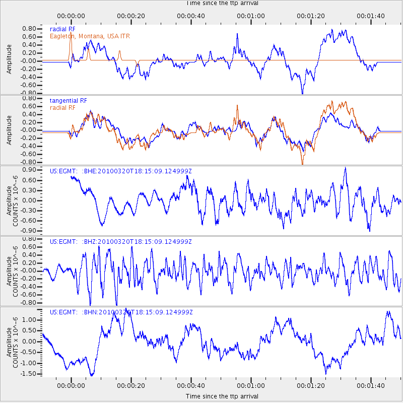
EGMT Eagleton, Montana, USA - Earthquake Result Viewer
*The percent match for this event was below the threshold and hence no stack was calculated.
| Earthquake location: |
Cuba Region |
| Earthquake latitude/longitude: |
19.7/-75.3 |
| Earthquake time(UTC): |
2010/03/20 (079) 18:08:08 GMT |
| Earthquake Depth: |
15 km |
| Earthquake Magnitude: |
5.5 MB, 5.4 MS, 5.6 MW, 5.6 MW |
| Earthquake Catalog/Contributor: |
WHDF/NEIC |
|
| Network: |
US United States National Seismic Network |
| Station: |
EGMT Eagleton, Montana, USA |
| Lat/Lon: |
48.02 N/109.75 W |
| Elevation: |
1055 m |
|
| Distance: |
39.7 deg |
| Az: |
323.515 deg |
| Baz: |
123.416 deg |
| Ray Param: |
$rayparam |
*The percent match for this event was below the threshold and hence was not used in the summary stack. |
|
| Radial Match: |
30.666325 % |
| Radial Bump: |
400 |
| Transverse Match: |
19.279549 % |
| Transverse Bump: |
400 |
| SOD ConfigId: |
308276 |
| Insert Time: |
2010-06-22 22:06:31.466 +0000 |
| GWidth: |
2.5 |
| Max Bumps: |
400 |
| Tol: |
0.001 |
|
Signal To Noise
| Channel | StoN | STA | LTA |
| US:EGMT: :BHZ:20100320T18:15:09.124999Z | 2.715327 | 2.6805594E-7 | 9.871959E-8 |
| US:EGMT: :BHN:20100320T18:15:09.124999Z | 0.81867874 | 8.300517E-7 | 1.0138918E-6 |
| US:EGMT: :BHE:20100320T18:15:09.124999Z | 0.47326764 | 1.746771E-7 | 3.6908733E-7 |
| Arrivals |
| Ps | |
| PpPs | |
| PsPs/PpSs | |


