You are here: Home > Network List > UW - Pacific Northwest Regional Seismic Network Stations List
> Station FISH2 Jewell, OR, USA > Earthquake Result Viewer
FISH2 Jewell, OR, USA - Earthquake Result Viewer
| Earthquake location: |
Southeast Of Loyalty Islands |
| Earthquake latitude/longitude: |
-23.1/170.4 |
| Earthquake time(UTC): |
2023/05/20 (140) 01:51:01 GMT |
| Earthquake Depth: |
45 km |
| Earthquake Magnitude: |
7.4 Mi |
| Earthquake Catalog/Contributor: |
NEIC PDE/at |
|
| Network: |
UW Pacific Northwest Regional Seismic Network |
| Station: |
FISH2 Jewell, OR, USA |
| Lat/Lon: |
45.93 N/123.50 W |
| Elevation: |
146 m |
|
| Distance: |
91.1 deg |
| Az: |
39.661 deg |
| Baz: |
237.349 deg |
| Ray Param: |
0.04163751 |
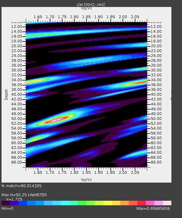
| Estimated Moho Depth: |
50.25 km |
| Estimated Crust Vp/Vs: |
1.73 |
| Assumed Crust Vp: |
6.566 km/s |
| Estimated Crust Vs: |
3.806 km/s |
| Estimated Crust Poisson's Ratio: |
0.25 |
|
| Radial Match: |
90.814285 % |
| Radial Bump: |
400 |
| Transverse Match: |
78.92275 % |
| Transverse Bump: |
400 |
| SOD ConfigId: |
30536071 |
| Insert Time: |
2023-06-03 02:18:51.789 +0000 |
| GWidth: |
2.5 |
| Max Bumps: |
400 |
| Tol: |
0.001 |
|

Signal To Noise
| Channel | StoN | STA | LTA |
| UW:FISH2: :HHZ:20230520T02:03:29.500Z | 4.9953628 | 9.892034E-7 | 1.9802434E-7 |
| UW:FISH2: :HHN:20230520T02:03:29.500Z | 1.9107891 | 4.251494E-7 | 2.2249938E-7 |
| UW:FISH2: :HHE:20230520T02:03:29.500Z | 1.2778931 | 3.6447994E-7 | 2.8521944E-7 |
| Arrivals |
| Ps | 5.7 SECOND |
| PpPs | 20 SECOND |
| PsPs/PpSs | 26 SECOND |


