You are here: Home > Network List > UW - Pacific Northwest Regional Seismic Network Stations List
> Station HOQUI City of Hoquiam Watershed, Hoquiam, WA, USA > Earthquake Result Viewer
HOQUI City of Hoquiam Watershed, Hoquiam, WA, USA - Earthquake Result Viewer
| Earthquake location: |
Southeast Of Loyalty Islands |
| Earthquake latitude/longitude: |
-23.1/170.4 |
| Earthquake time(UTC): |
2023/05/20 (140) 01:51:01 GMT |
| Earthquake Depth: |
45 km |
| Earthquake Magnitude: |
7.4 Mi |
| Earthquake Catalog/Contributor: |
NEIC PDE/at |
|
| Network: |
UW Pacific Northwest Regional Seismic Network |
| Station: |
HOQUI City of Hoquiam Watershed, Hoquiam, WA, USA |
| Lat/Lon: |
47.08 N/123.96 W |
| Elevation: |
101 m |
|
| Distance: |
91.4 deg |
| Az: |
38.52 deg |
| Baz: |
237.044 deg |
| Ray Param: |
0.04159427 |
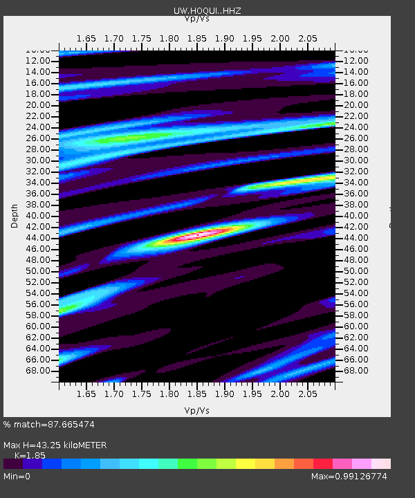
| Estimated Moho Depth: |
43.25 km |
| Estimated Crust Vp/Vs: |
1.85 |
| Assumed Crust Vp: |
6.566 km/s |
| Estimated Crust Vs: |
3.549 km/s |
| Estimated Crust Poisson's Ratio: |
0.29 |
|
| Radial Match: |
87.665474 % |
| Radial Bump: |
345 |
| Transverse Match: |
80.50974 % |
| Transverse Bump: |
363 |
| SOD ConfigId: |
30536071 |
| Insert Time: |
2023-06-03 02:19:12.148 +0000 |
| GWidth: |
2.5 |
| Max Bumps: |
400 |
| Tol: |
0.001 |
|

Signal To Noise
| Channel | StoN | STA | LTA |
| UW:HOQUI: :HHZ:20230520T02:03:31.159973Z | 3.2809765 | 1.1738024E-6 | 3.577601E-7 |
| UW:HOQUI: :HHN:20230520T02:03:31.159973Z | 0.8800137 | 4.5287095E-7 | 5.146181E-7 |
| UW:HOQUI: :HHE:20230520T02:03:31.159973Z | 1.0645862 | 5.087925E-7 | 4.7792514E-7 |
| Arrivals |
| Ps | 5.7 SECOND |
| PpPs | 18 SECOND |
| PsPs/PpSs | 24 SECOND |


