You are here: Home > Network List > UW - Pacific Northwest Regional Seismic Network Stations List
> Station LCV Les Collines Vineyard, Walla Walla, WA, USA > Earthquake Result Viewer
LCV Les Collines Vineyard, Walla Walla, WA, USA - Earthquake Result Viewer
| Earthquake location: |
Southeast Of Loyalty Islands |
| Earthquake latitude/longitude: |
-23.1/170.4 |
| Earthquake time(UTC): |
2023/05/20 (140) 01:51:01 GMT |
| Earthquake Depth: |
45 km |
| Earthquake Magnitude: |
7.4 Mi |
| Earthquake Catalog/Contributor: |
NEIC PDE/at |
|
| Network: |
UW Pacific Northwest Regional Seismic Network |
| Station: |
LCV Les Collines Vineyard, Walla Walla, WA, USA |
| Lat/Lon: |
46.01 N/118.28 W |
| Elevation: |
361 m |
|
| Distance: |
94.3 deg |
| Az: |
41.46 deg |
| Baz: |
241.009 deg |
| Ray Param: |
0.04106534 |
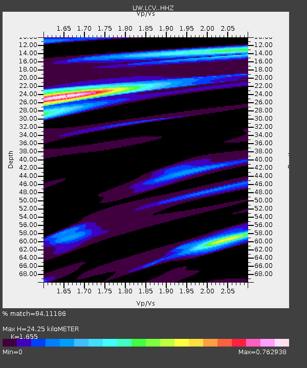
| Estimated Moho Depth: |
24.25 km |
| Estimated Crust Vp/Vs: |
1.65 |
| Assumed Crust Vp: |
6.419 km/s |
| Estimated Crust Vs: |
3.879 km/s |
| Estimated Crust Poisson's Ratio: |
0.21 |
|
| Radial Match: |
94.11186 % |
| Radial Bump: |
400 |
| Transverse Match: |
89.39469 % |
| Transverse Bump: |
400 |
| SOD ConfigId: |
30536071 |
| Insert Time: |
2023-06-03 02:19:31.012 +0000 |
| GWidth: |
2.5 |
| Max Bumps: |
400 |
| Tol: |
0.001 |
|

Signal To Noise
| Channel | StoN | STA | LTA |
| UW:LCV: :HHZ:20230520T02:03:44.059998Z | 5.25665 | 7.94382E-7 | 1.5111944E-7 |
| UW:LCV: :HHN:20230520T02:03:44.059998Z | 0.85144216 | 9.8470565E-8 | 1.156515E-7 |
| UW:LCV: :HHE:20230520T02:03:44.059998Z | 1.0438722 | 1.3458053E-7 | 1.2892433E-7 |
| Arrivals |
| Ps | 2.5 SECOND |
| PpPs | 9.8 SECOND |
| PsPs/PpSs | 12 SECOND |


