You are here: Home > Network List > UW - Pacific Northwest Regional Seismic Network Stations List
> Station LUMI Lummi Island, WA > Earthquake Result Viewer
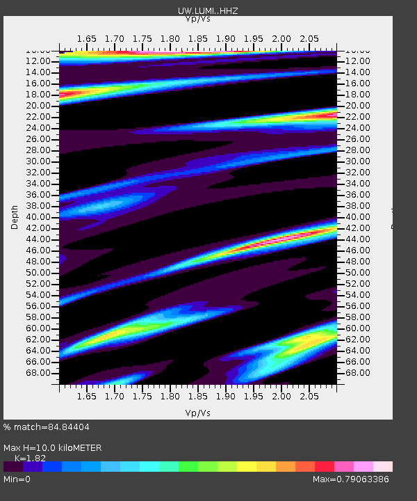
LUMI Lummi Island, WA - Earthquake Result Viewer
| Earthquake location: |
Southeast Of Loyalty Islands |
| Earthquake latitude/longitude: |
-23.1/170.4 |
| Earthquake time(UTC): |
2023/05/20 (140) 01:51:01 GMT |
| Earthquake Depth: |
45 km |
| Earthquake Magnitude: |
7.4 Mi |
| Earthquake Catalog/Contributor: |
NEIC PDE/at |
|
| Network: |
UW Pacific Northwest Regional Seismic Network |
| Station: |
LUMI Lummi Island, WA |
| Lat/Lon: |
48.72 N/122.71 W |
| Elevation: |
19 m |
|
| Distance: |
93.0 deg |
| Az: |
37.587 deg |
| Baz: |
238.005 deg |
| Ray Param: |
0.041330285 |
| Estimated Moho Depth: |
10.0 km |
| Estimated Crust Vp/Vs: |
1.82 |
| Assumed Crust Vp: |
6.566 km/s |
| Estimated Crust Vs: |
3.608 km/s |
| Estimated Crust Poisson's Ratio: |
0.28 |
|
| Radial Match: |
84.84404 % |
| Radial Bump: |
400 |
| Transverse Match: |
83.79648 % |
| Transverse Bump: |
400 |
| SOD ConfigId: |
30536071 |
| Insert Time: |
2023-06-03 02:19:46.773 +0000 |
| GWidth: |
2.5 |
| Max Bumps: |
400 |
| Tol: |
0.001 |
|

Signal To Noise
| Channel | StoN | STA | LTA |
| UW:LUMI: :HHZ:20230520T02:03:38.47998Z | 5.534056 | 7.6888404E-7 | 1.389368E-7 |
| UW:LUMI: :HHN:20230520T02:03:38.47998Z | 1.757126 | 2.3188923E-7 | 1.3197075E-7 |
| UW:LUMI: :HHE:20230520T02:03:38.47998Z | 1.822524 | 3.239781E-7 | 1.7776343E-7 |
| Arrivals |
| Ps | 1.3 SECOND |
| PpPs | 4.2 SECOND |
| PsPs/PpSs | 5.5 SECOND |


