You are here: Home > Network List > UW - Pacific Northwest Regional Seismic Network Stations List
> Station SKOKO Rock Peak, WA, USA > Earthquake Result Viewer
SKOKO Rock Peak, WA, USA - Earthquake Result Viewer
| Earthquake location: |
Southeast Of Loyalty Islands |
| Earthquake latitude/longitude: |
-23.1/170.4 |
| Earthquake time(UTC): |
2023/05/20 (140) 01:51:01 GMT |
| Earthquake Depth: |
45 km |
| Earthquake Magnitude: |
7.4 Mi |
| Earthquake Catalog/Contributor: |
NEIC PDE/at |
|
| Network: |
UW Pacific Northwest Regional Seismic Network |
| Station: |
SKOKO Rock Peak, WA, USA |
| Lat/Lon: |
47.41 N/123.37 W |
| Elevation: |
950 m |
|
| Distance: |
92.0 deg |
| Az: |
38.461 deg |
| Baz: |
237.477 deg |
| Ray Param: |
0.04152056 |
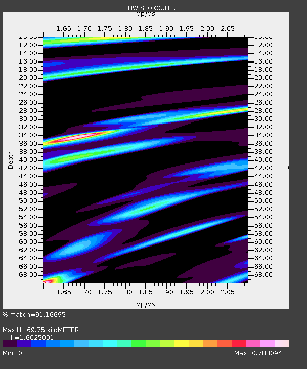
| Estimated Moho Depth: |
69.75 km |
| Estimated Crust Vp/Vs: |
1.60 |
| Assumed Crust Vp: |
6.566 km/s |
| Estimated Crust Vs: |
4.097 km/s |
| Estimated Crust Poisson's Ratio: |
0.18 |
|
| Radial Match: |
91.16695 % |
| Radial Bump: |
400 |
| Transverse Match: |
89.0289 % |
| Transverse Bump: |
400 |
| SOD ConfigId: |
30536071 |
| Insert Time: |
2023-06-03 02:20:46.710 +0000 |
| GWidth: |
2.5 |
| Max Bumps: |
400 |
| Tol: |
0.001 |
|

Signal To Noise
| Channel | StoN | STA | LTA |
| UW:SKOKO: :HHZ:20230520T02:03:33.539978Z | 9.288869 | 8.522052E-7 | 9.174477E-8 |
| UW:SKOKO: :HHN:20230520T02:03:33.539978Z | 3.0994332 | 2.4861055E-7 | 8.021162E-8 |
| UW:SKOKO: :HHE:20230520T02:03:33.539978Z | 2.4358902 | 2.0859231E-7 | 8.563289E-8 |
| Arrivals |
| Ps | 6.6 SECOND |
| PpPs | 27 SECOND |
| PsPs/PpSs | 34 SECOND |


