You are here: Home > Network List > TA - USArray Transportable Network (new EarthScope stations) Stations List
> Station X18A Snowflake, AZ, USA > Earthquake Result Viewer
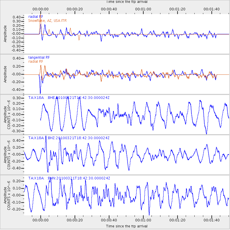
X18A Snowflake, AZ, USA - Earthquake Result Viewer
*The percent match for this event was below the threshold and hence no stack was calculated.
| Earthquake location: |
Near Coast Of Central Chile |
| Earthquake latitude/longitude: |
-36.3/-73.2 |
| Earthquake time(UTC): |
2010/03/21 (080) 18:31:04 GMT |
| Earthquake Depth: |
36 km |
| Earthquake Magnitude: |
5.6 MB, 5.1 MS, 5.5 MW, 5.5 MW |
| Earthquake Catalog/Contributor: |
WHDF/NEIC |
|
| Network: |
TA USArray Transportable Network (new EarthScope stations) |
| Station: |
X18A Snowflake, AZ, USA |
| Lat/Lon: |
34.53 N/109.95 W |
| Elevation: |
1751 m |
|
| Distance: |
78.4 deg |
| Az: |
329.689 deg |
| Baz: |
150.427 deg |
| Ray Param: |
$rayparam |
*The percent match for this event was below the threshold and hence was not used in the summary stack. |
|
| Radial Match: |
62.392693 % |
| Radial Bump: |
400 |
| Transverse Match: |
51.01397 % |
| Transverse Bump: |
324 |
| SOD ConfigId: |
308276 |
| Insert Time: |
2010-06-22 22:12:12.760 +0000 |
| GWidth: |
2.5 |
| Max Bumps: |
400 |
| Tol: |
0.001 |
|
Signal To Noise
| Channel | StoN | STA | LTA |
| TA:X18A: :BHZ:20100321T18:42:30.000024Z | 2.1196527 | 2.5969197E-7 | 1.2251628E-7 |
| TA:X18A: :BHN:20100321T18:42:30.000024Z | 1.2509153 | 1.1661672E-7 | 9.322511E-8 |
| TA:X18A: :BHE:20100321T18:42:30.000024Z | 0.45730346 | 8.735699E-8 | 1.910263E-7 |
| Arrivals |
| Ps | |
| PpPs | |
| PsPs/PpSs | |


