You are here: Home > Network List > UW - Pacific Northwest Regional Seismic Network Stations List
> Station TREE Summer Lake, OR, USA > Earthquake Result Viewer
TREE Summer Lake, OR, USA - Earthquake Result Viewer
| Earthquake location: |
Southeast Of Loyalty Islands |
| Earthquake latitude/longitude: |
-23.1/170.4 |
| Earthquake time(UTC): |
2023/05/20 (140) 01:51:01 GMT |
| Earthquake Depth: |
45 km |
| Earthquake Magnitude: |
7.4 Mi |
| Earthquake Catalog/Contributor: |
NEIC PDE/at |
|
| Network: |
UW Pacific Northwest Regional Seismic Network |
| Station: |
TREE Summer Lake, OR, USA |
| Lat/Lon: |
42.73 N/120.89 W |
| Elevation: |
1881 m |
|
| Distance: |
91.0 deg |
| Az: |
43.367 deg |
| Baz: |
239.097 deg |
| Ray Param: |
0.041647825 |
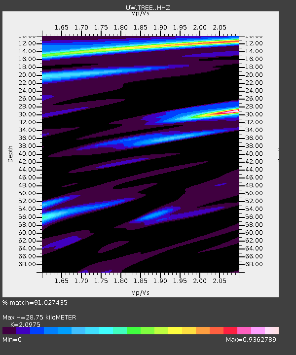
| Estimated Moho Depth: |
28.75 km |
| Estimated Crust Vp/Vs: |
2.10 |
| Assumed Crust Vp: |
6.597 km/s |
| Estimated Crust Vs: |
3.145 km/s |
| Estimated Crust Poisson's Ratio: |
0.35 |
|
| Radial Match: |
91.027435 % |
| Radial Bump: |
326 |
| Transverse Match: |
87.36376 % |
| Transverse Bump: |
400 |
| SOD ConfigId: |
30536071 |
| Insert Time: |
2023-06-03 02:21:13.376 +0000 |
| GWidth: |
2.5 |
| Max Bumps: |
400 |
| Tol: |
0.001 |
|
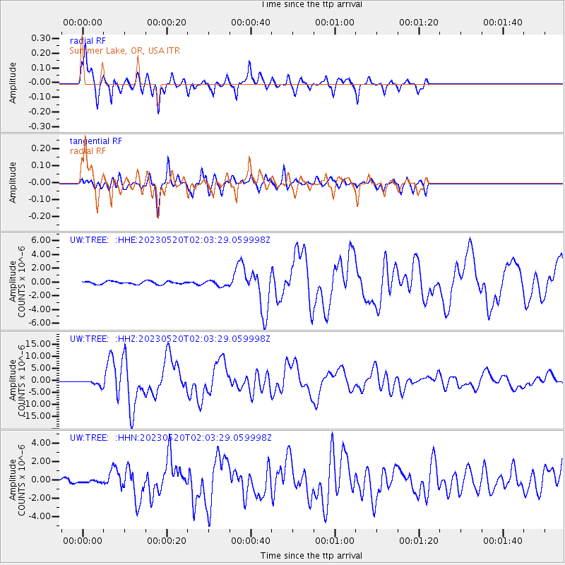
Signal To Noise
| Channel | StoN | STA | LTA |
| UW:TREE: :HHZ:20230520T02:03:29.059998Z | 6.442163 | 1.1864788E-6 | 1.8417397E-7 |
| UW:TREE: :HHN:20230520T02:03:29.059998Z | 0.56081295 | 9.441019E-8 | 1.6834524E-7 |
| UW:TREE: :HHE:20230520T02:03:29.059998Z | 1.9672098 | 4.0621592E-7 | 2.0649344E-7 |
| Arrivals |
| Ps | 4.9 SECOND |
| PpPs | 13 SECOND |
| PsPs/PpSs | 18 SECOND |


