You are here: Home > Network List > UW - Pacific Northwest Regional Seismic Network Stations List
> Station UMAT Pilot Rock, OR, USA > Earthquake Result Viewer
UMAT Pilot Rock, OR, USA - Earthquake Result Viewer
| Earthquake location: |
Southeast Of Loyalty Islands |
| Earthquake latitude/longitude: |
-23.1/170.4 |
| Earthquake time(UTC): |
2023/05/20 (140) 01:51:01 GMT |
| Earthquake Depth: |
45 km |
| Earthquake Magnitude: |
7.4 Mi |
| Earthquake Catalog/Contributor: |
NEIC PDE/at |
|
| Network: |
UW Pacific Northwest Regional Seismic Network |
| Station: |
UMAT Pilot Rock, OR, USA |
| Lat/Lon: |
45.29 N/118.96 W |
| Elevation: |
1318 m |
|
| Distance: |
93.5 deg |
| Az: |
41.853 deg |
| Baz: |
240.496 deg |
| Ray Param: |
0.04123755 |
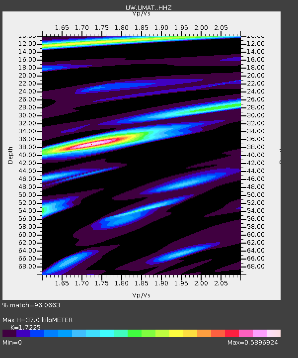
| Estimated Moho Depth: |
37.0 km |
| Estimated Crust Vp/Vs: |
1.72 |
| Assumed Crust Vp: |
6.571 km/s |
| Estimated Crust Vs: |
3.815 km/s |
| Estimated Crust Poisson's Ratio: |
0.25 |
|
| Radial Match: |
96.0663 % |
| Radial Bump: |
328 |
| Transverse Match: |
89.49948 % |
| Transverse Bump: |
384 |
| SOD ConfigId: |
30536071 |
| Insert Time: |
2023-06-03 02:21:16.834 +0000 |
| GWidth: |
2.5 |
| Max Bumps: |
400 |
| Tol: |
0.001 |
|

Signal To Noise
| Channel | StoN | STA | LTA |
| UW:UMAT: :HHZ:20230520T02:03:40.549988Z | 4.9046836 | 7.4577184E-7 | 1.5205299E-7 |
| UW:UMAT: :HHN:20230520T02:03:40.549988Z | 0.9889532 | 9.864584E-8 | 9.9747744E-8 |
| UW:UMAT: :HHE:20230520T02:03:40.549988Z | 2.6225762 | 1.7444953E-7 | 6.651838E-8 |
| Arrivals |
| Ps | 4.2 SECOND |
| PpPs | 15 SECOND |
| PsPs/PpSs | 19 SECOND |


