You are here: Home > Network List > UW - Pacific Northwest Regional Seismic Network Stations List
> Station WYNO Wynoochee Dam Area, Olympic National Forest, WA, USA > Earthquake Result Viewer
WYNO Wynoochee Dam Area, Olympic National Forest, WA, USA - Earthquake Result Viewer
| Earthquake location: |
Southeast Of Loyalty Islands |
| Earthquake latitude/longitude: |
-23.1/170.4 |
| Earthquake time(UTC): |
2023/05/20 (140) 01:51:01 GMT |
| Earthquake Depth: |
45 km |
| Earthquake Magnitude: |
7.4 Mi |
| Earthquake Catalog/Contributor: |
NEIC PDE/at |
|
| Network: |
UW Pacific Northwest Regional Seismic Network |
| Station: |
WYNO Wynoochee Dam Area, Olympic National Forest, WA, USA |
| Lat/Lon: |
47.43 N/123.61 W |
| Elevation: |
935 m |
|
| Distance: |
91.8 deg |
| Az: |
38.35 deg |
| Baz: |
237.3 deg |
| Ray Param: |
0.041539975 |
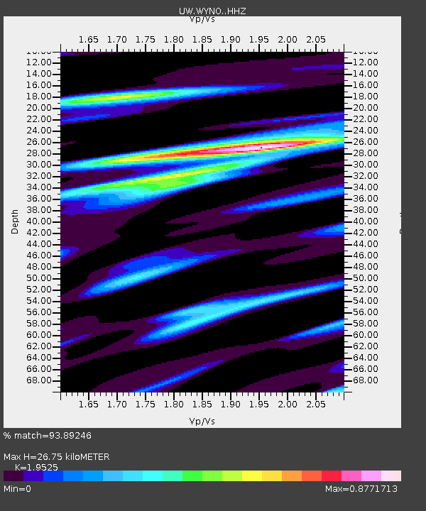
| Estimated Moho Depth: |
26.75 km |
| Estimated Crust Vp/Vs: |
1.95 |
| Assumed Crust Vp: |
6.566 km/s |
| Estimated Crust Vs: |
3.363 km/s |
| Estimated Crust Poisson's Ratio: |
0.32 |
|
| Radial Match: |
93.89246 % |
| Radial Bump: |
400 |
| Transverse Match: |
71.077484 % |
| Transverse Bump: |
400 |
| SOD ConfigId: |
30536071 |
| Insert Time: |
2023-06-03 02:21:34.212 +0000 |
| GWidth: |
2.5 |
| Max Bumps: |
400 |
| Tol: |
0.001 |
|

Signal To Noise
| Channel | StoN | STA | LTA |
| UW:WYNO: :HHZ:20230520T02:03:32.950012Z | 7.223373 | 7.682831E-7 | 1.0636071E-7 |
| UW:WYNO: :HHN:20230520T02:03:32.950012Z | 1.9880768 | 3.0428563E-7 | 1.5305527E-7 |
| UW:WYNO: :HHE:20230520T02:03:32.950012Z | 2.5255132 | 2.8351673E-7 | 1.12261034E-7 |
| Arrivals |
| Ps | 4.0 SECOND |
| PpPs | 12 SECOND |
| PsPs/PpSs | 16 SECOND |


