You are here: Home > Network List > WW - Idaho Seismic Network () Stations List
> Station BILL Emerald Creek, Idaho > Earthquake Result Viewer
BILL Emerald Creek, Idaho - Earthquake Result Viewer
| Earthquake location: |
Southeast Of Loyalty Islands |
| Earthquake latitude/longitude: |
-23.1/170.4 |
| Earthquake time(UTC): |
2023/05/20 (140) 01:51:01 GMT |
| Earthquake Depth: |
45 km |
| Earthquake Magnitude: |
7.4 Mi |
| Earthquake Catalog/Contributor: |
NEIC PDE/at |
|
| Network: |
WW Idaho Seismic Network () |
| Station: |
BILL Emerald Creek, Idaho |
| Lat/Lon: |
47.03 N/116.34 W |
| Elevation: |
866 m |
|
| Distance: |
95.9 deg |
| Az: |
41.19 deg |
| Baz: |
242.435 deg |
| Ray Param: |
0.04063663 |
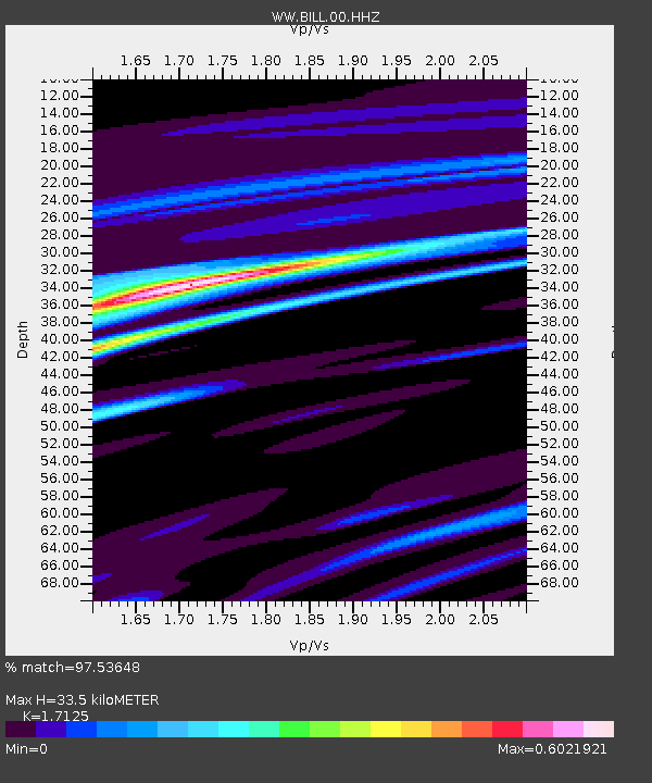
| Estimated Moho Depth: |
33.5 km |
| Estimated Crust Vp/Vs: |
1.71 |
| Assumed Crust Vp: |
6.571 km/s |
| Estimated Crust Vs: |
3.837 km/s |
| Estimated Crust Poisson's Ratio: |
0.24 |
|
| Radial Match: |
97.53648 % |
| Radial Bump: |
395 |
| Transverse Match: |
76.71368 % |
| Transverse Bump: |
400 |
| SOD ConfigId: |
30536071 |
| Insert Time: |
2023-06-03 02:21:51.490 +0000 |
| GWidth: |
2.5 |
| Max Bumps: |
400 |
| Tol: |
0.001 |
|

Signal To Noise
| Channel | StoN | STA | LTA |
| WW:BILL:00:HHZ:20230520T02:03:51.599976Z | 9.7889185 | 8.19019E-7 | 8.366798E-8 |
| WW:BILL:00:HHN:20230520T02:03:51.599976Z | 1.4857278 | 1.1449765E-7 | 7.706503E-8 |
| WW:BILL:00:HHE:20230520T02:03:51.599976Z | 2.7794137 | 2.0987957E-7 | 7.5512176E-8 |
| Arrivals |
| Ps | 3.7 SECOND |
| PpPs | 14 SECOND |
| PsPs/PpSs | 17 SECOND |


