You are here: Home > Network List > TA - USArray Transportable Network (new EarthScope stations) Stations List
> Station O22A Kremmling, CO, USA > Earthquake Result Viewer
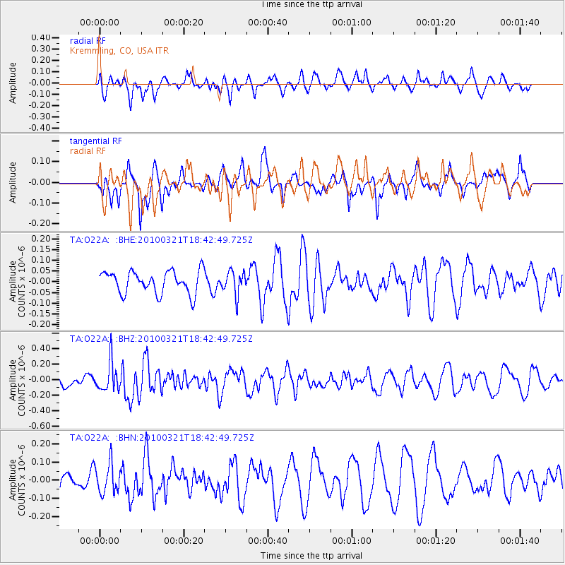
O22A Kremmling, CO, USA - Earthquake Result Viewer
*The percent match for this event was below the threshold and hence no stack was calculated.
| Earthquake location: |
Near Coast Of Central Chile |
| Earthquake latitude/longitude: |
-36.3/-73.2 |
| Earthquake time(UTC): |
2010/03/21 (080) 18:31:04 GMT |
| Earthquake Depth: |
36 km |
| Earthquake Magnitude: |
5.6 MB, 5.1 MS, 5.5 MW, 5.5 MW |
| Earthquake Catalog/Contributor: |
WHDF/NEIC |
|
| Network: |
TA USArray Transportable Network (new EarthScope stations) |
| Station: |
O22A Kremmling, CO, USA |
| Lat/Lon: |
40.16 N/106.55 W |
| Elevation: |
2747 m |
|
| Distance: |
82.1 deg |
| Az: |
334.804 deg |
| Baz: |
153.352 deg |
| Ray Param: |
$rayparam |
*The percent match for this event was below the threshold and hence was not used in the summary stack. |
|
| Radial Match: |
43.869713 % |
| Radial Bump: |
400 |
| Transverse Match: |
51.873886 % |
| Transverse Bump: |
306 |
| SOD ConfigId: |
308276 |
| Insert Time: |
2010-06-22 22:14:51.255 +0000 |
| GWidth: |
2.5 |
| Max Bumps: |
400 |
| Tol: |
0.001 |
|
Signal To Noise
| Channel | StoN | STA | LTA |
| TA:O22A: :BHZ:20100321T18:42:49.725Z | 2.1882303 | 1.921621E-7 | 8.781621E-8 |
| TA:O22A: :BHN:20100321T18:42:49.725Z | 0.86706597 | 8.1382424E-8 | 9.3859555E-8 |
| TA:O22A: :BHE:20100321T18:42:49.725Z | 1.0617083 | 5.535552E-8 | 5.2138162E-8 |
| Arrivals |
| Ps | |
| PpPs | |
| PsPs/PpSs | |


