You are here: Home > Network List > TA - USArray Transportable Network (new EarthScope stations) Stations List
> Station M23A Laramie, WY, USA > Earthquake Result Viewer
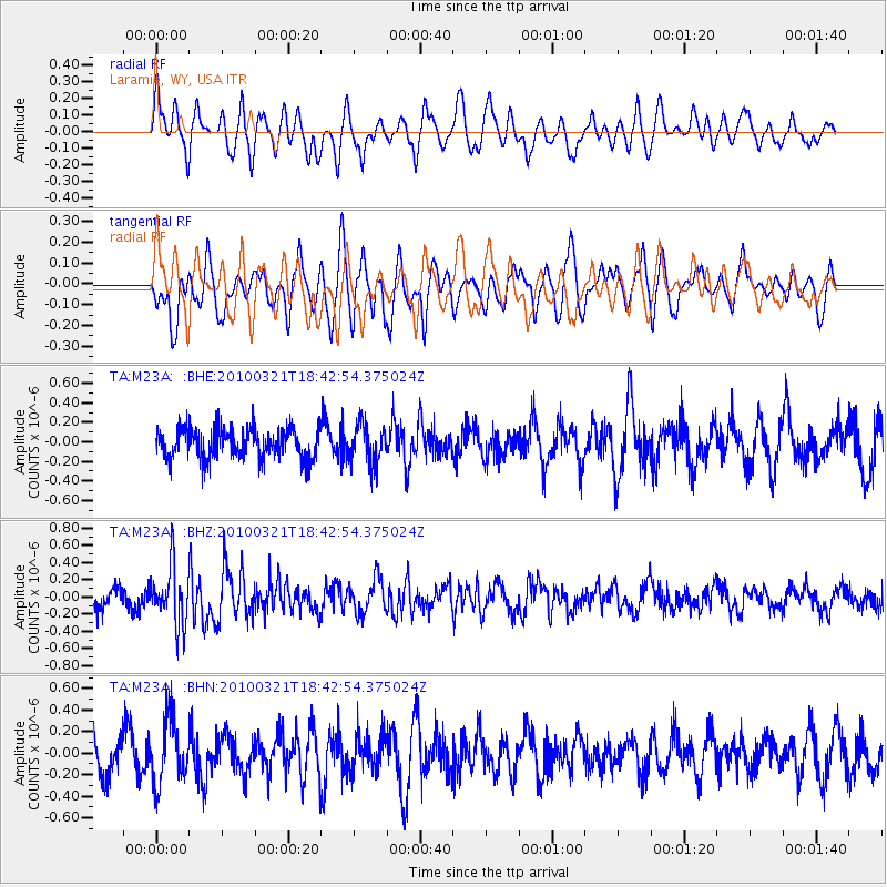
M23A Laramie, WY, USA - Earthquake Result Viewer
*The percent match for this event was below the threshold and hence no stack was calculated.
| Earthquake location: |
Near Coast Of Central Chile |
| Earthquake latitude/longitude: |
-36.3/-73.2 |
| Earthquake time(UTC): |
2010/03/21 (080) 18:31:04 GMT |
| Earthquake Depth: |
36 km |
| Earthquake Magnitude: |
5.6 MB, 5.1 MS, 5.5 MW, 5.5 MW |
| Earthquake Catalog/Contributor: |
WHDF/NEIC |
|
| Network: |
TA USArray Transportable Network (new EarthScope stations) |
| Station: |
M23A Laramie, WY, USA |
| Lat/Lon: |
41.47 N/105.72 W |
| Elevation: |
2166 m |
|
| Distance: |
83.0 deg |
| Az: |
335.953 deg |
| Baz: |
154.039 deg |
| Ray Param: |
$rayparam |
*The percent match for this event was below the threshold and hence was not used in the summary stack. |
|
| Radial Match: |
62.273872 % |
| Radial Bump: |
400 |
| Transverse Match: |
53.523838 % |
| Transverse Bump: |
400 |
| SOD ConfigId: |
308276 |
| Insert Time: |
2010-06-22 22:15:34.120 +0000 |
| GWidth: |
2.5 |
| Max Bumps: |
400 |
| Tol: |
0.001 |
|
Signal To Noise
| Channel | StoN | STA | LTA |
| TA:M23A: :BHZ:20100321T18:42:54.375024Z | 2.7304637 | 3.3658023E-7 | 1.2326852E-7 |
| TA:M23A: :BHN:20100321T18:42:54.375024Z | 1.7108902 | 2.976036E-7 | 1.7394663E-7 |
| TA:M23A: :BHE:20100321T18:42:54.375024Z | 1.2827907 | 1.9854662E-7 | 1.547771E-7 |
| Arrivals |
| Ps | |
| PpPs | |
| PsPs/PpSs | |


