You are here: Home > Network List > G - GEOSCOPE Stations List
> Station INU Inuyama, Japan > Earthquake Result Viewer
INU Inuyama, Japan - Earthquake Result Viewer
*The percent match for this event was below the threshold and hence no stack was calculated.
| Earthquake location: |
Tonga Islands |
| Earthquake latitude/longitude: |
-19.4/-173.3 |
| Earthquake time(UTC): |
2023/05/21 (141) 05:23:11 GMT |
| Earthquake Depth: |
10 km |
| Earthquake Magnitude: |
5.8 Mww |
| Earthquake Catalog/Contributor: |
NEIC PDE/us |
|
| Network: |
G GEOSCOPE |
| Station: |
INU Inuyama, Japan |
| Lat/Lon: |
35.35 N/137.03 E |
| Elevation: |
132 m |
|
| Distance: |
72.0 deg |
| Az: |
319.076 deg |
| Baz: |
130.858 deg |
| Ray Param: |
$rayparam |
*The percent match for this event was below the threshold and hence was not used in the summary stack. |
|
| Radial Match: |
67.245834 % |
| Radial Bump: |
399 |
| Transverse Match: |
54.72046 % |
| Transverse Bump: |
400 |
| SOD ConfigId: |
30536071 |
| Insert Time: |
2023-06-04 05:33:19.628 +0000 |
| GWidth: |
2.5 |
| Max Bumps: |
400 |
| Tol: |
0.001 |
|
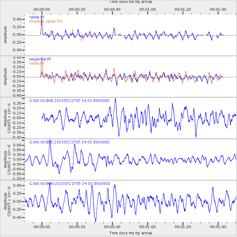
Signal To Noise
| Channel | StoN | STA | LTA |
| G:INU:00:BHZ:20230521T05:34:03.860999Z | 4.166326 | 4.7182488E-7 | 1.1324723E-7 |
| G:INU:00:BHN:20230521T05:34:03.860999Z | 1.4875045 | 2.0379991E-7 | 1.3700793E-7 |
| G:INU:00:BHE:20230521T05:34:03.860999Z | 1.0399693 | 8.907285E-8 | 8.56495E-8 |
| Arrivals |
| Ps | |
| PpPs | |
| PsPs/PpSs | |


