You are here: Home > Network List > GM - US Geological Survey Networks Stations List
> Station IWM01 Jericho 2M Well Monitoring Station > Earthquake Result Viewer
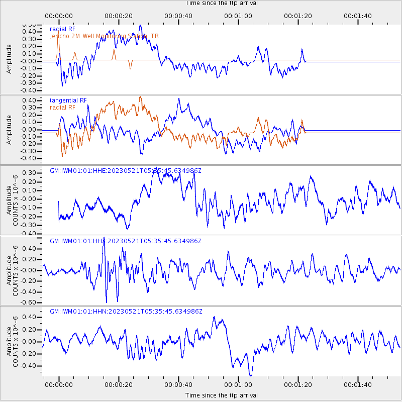
IWM01 Jericho 2M Well Monitoring Station - Earthquake Result Viewer
*The percent match for this event was below the threshold and hence no stack was calculated.
| Earthquake location: |
Tonga Islands |
| Earthquake latitude/longitude: |
-19.4/-173.3 |
| Earthquake time(UTC): |
2023/05/21 (141) 05:23:11 GMT |
| Earthquake Depth: |
10 km |
| Earthquake Magnitude: |
5.8 Mww |
| Earthquake Catalog/Contributor: |
NEIC PDE/us |
|
| Network: |
GM US Geological Survey Networks |
| Station: |
IWM01 Jericho 2M Well Monitoring Station |
| Lat/Lon: |
36.73 N/96.53 W |
| Elevation: |
328 m |
|
| Distance: |
91.3 deg |
| Az: |
51.48 deg |
| Baz: |
246.801 deg |
| Ray Param: |
$rayparam |
*The percent match for this event was below the threshold and hence was not used in the summary stack. |
|
| Radial Match: |
35.127598 % |
| Radial Bump: |
400 |
| Transverse Match: |
42.874336 % |
| Transverse Bump: |
400 |
| SOD ConfigId: |
30536071 |
| Insert Time: |
2023-06-04 05:33:41.748 +0000 |
| GWidth: |
2.5 |
| Max Bumps: |
400 |
| Tol: |
0.001 |
|
Signal To Noise
| Channel | StoN | STA | LTA |
| GM:IWM01:01:HHZ:20230521T05:35:45.634986Z | 0.43087563 | 2.4570232E-8 | 5.7023954E-8 |
| GM:IWM01:01:HHN:20230521T05:35:45.634986Z | 0.6075692 | 9.713729E-8 | 1.5987855E-7 |
| GM:IWM01:01:HHE:20230521T05:35:45.634986Z | 4.7629333 | 3.72493E-7 | 7.820663E-8 |
| Arrivals |
| Ps | |
| PpPs | |
| PsPs/PpSs | |


