You are here: Home > Network List > WI - West Indies IPGP Network Stations List
> Station BIM Morne Bigot, Anses d'Arlets, Martinique > Earthquake Result Viewer
BIM Morne Bigot, Anses d'Arlets, Martinique - Earthquake Result Viewer
| Earthquake location: |
Drake Passage |
| Earthquake latitude/longitude: |
-57.4/-66.4 |
| Earthquake time(UTC): |
2018/10/29 (302) 06:54:21 GMT |
| Earthquake Depth: |
10 km |
| Earthquake Magnitude: |
6.3 Mww |
| Earthquake Catalog/Contributor: |
NEIC PDE/us |
|
| Network: |
WI West Indies IPGP Network |
| Station: |
BIM Morne Bigot, Anses d'Arlets, Martinique |
| Lat/Lon: |
14.52 N/61.07 W |
| Elevation: |
391 m |
|
| Distance: |
71.8 deg |
| Az: |
5.447 deg |
| Baz: |
183.041 deg |
| Ray Param: |
0.05409176 |
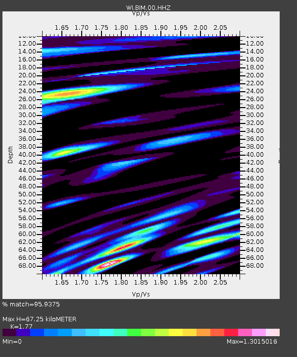
| Estimated Moho Depth: |
67.25 km |
| Estimated Crust Vp/Vs: |
1.77 |
| Assumed Crust Vp: |
5.88 km/s |
| Estimated Crust Vs: |
3.322 km/s |
| Estimated Crust Poisson's Ratio: |
0.27 |
|
| Radial Match: |
95.9375 % |
| Radial Bump: |
400 |
| Transverse Match: |
93.72456 % |
| Transverse Bump: |
400 |
| SOD ConfigId: |
3103472 |
| Insert Time: |
2018-11-12 07:04:38.117 +0000 |
| GWidth: |
2.5 |
| Max Bumps: |
400 |
| Tol: |
0.001 |
|
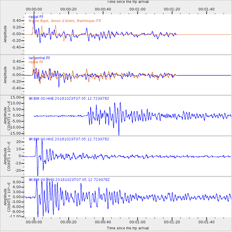
Signal To Noise
| Channel | StoN | STA | LTA |
| WI:BIM:00:HHZ:20181029T07:05:12.729978Z | 48.71627 | 1.1394604E-5 | 2.338973E-7 |
| WI:BIM:00:HHN:20181029T07:05:12.729978Z | 22.335312 | 5.218086E-6 | 2.3362492E-7 |
| WI:BIM:00:HHE:20181029T07:05:12.729978Z | 18.057085 | 3.22857E-6 | 1.7879796E-7 |
| Arrivals |
| Ps | 9.1 SECOND |
| PpPs | 31 SECOND |
| PsPs/PpSs | 40 SECOND |


