You are here: Home > Network List > G - GEOSCOPE Stations List
> Station TAM Tamanrasset, Algeria > Earthquake Result Viewer
TAM Tamanrasset, Algeria - Earthquake Result Viewer
| Earthquake location: |
Prince Edward Islands Region |
| Earthquake latitude/longitude: |
-43.4/39.4 |
| Earthquake time(UTC): |
2023/05/21 (141) 14:56:45 GMT |
| Earthquake Depth: |
10 km |
| Earthquake Magnitude: |
6.8 mww |
| Earthquake Catalog/Contributor: |
NEIC PDE/us |
|
| Network: |
G GEOSCOPE |
| Station: |
TAM Tamanrasset, Algeria |
| Lat/Lon: |
22.79 N/5.53 E |
| Elevation: |
1377 m |
|
| Distance: |
72.9 deg |
| Az: |
327.468 deg |
| Baz: |
154.882 deg |
| Ray Param: |
0.05338564 |
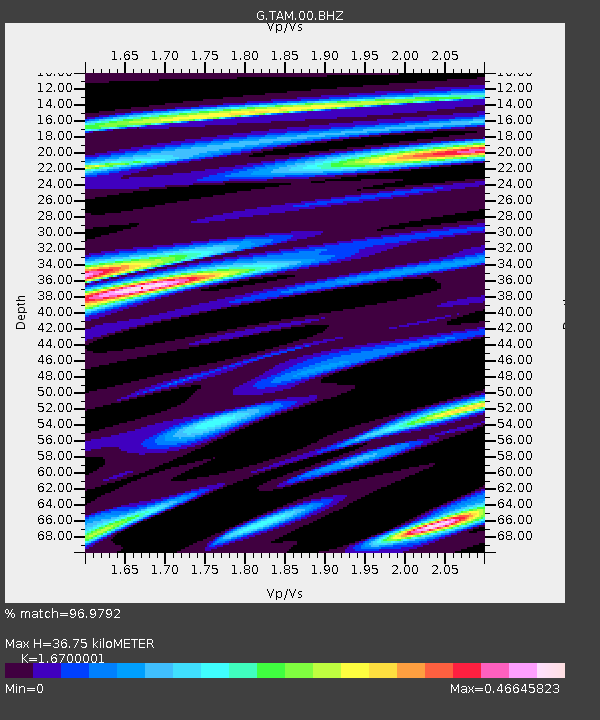
| Estimated Moho Depth: |
36.75 km |
| Estimated Crust Vp/Vs: |
1.67 |
| Assumed Crust Vp: |
6.61 km/s |
| Estimated Crust Vs: |
3.958 km/s |
| Estimated Crust Poisson's Ratio: |
0.22 |
|
| Radial Match: |
96.9792 % |
| Radial Bump: |
327 |
| Transverse Match: |
75.25445 % |
| Transverse Bump: |
400 |
| SOD ConfigId: |
30536071 |
| Insert Time: |
2023-06-04 14:59:45.630 +0000 |
| GWidth: |
2.5 |
| Max Bumps: |
400 |
| Tol: |
0.001 |
|
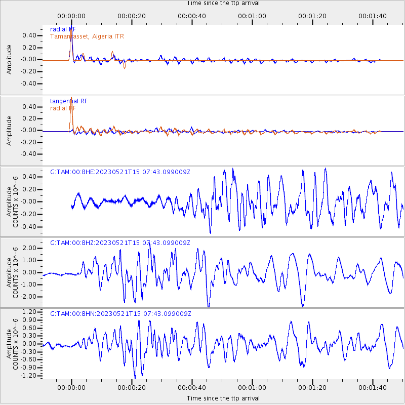
Signal To Noise
| Channel | StoN | STA | LTA |
| G:TAM:00:BHZ:20230521T15:07:43.099009Z | 3.955228 | 3.2476726E-7 | 8.211089E-8 |
| G:TAM:00:BHN:20230521T15:07:43.099009Z | 2.1040316 | 9.84795E-8 | 4.680514E-8 |
| G:TAM:00:BHE:20230521T15:07:43.099009Z | 1.5632397 | 7.9526046E-8 | 5.087259E-8 |
| Arrivals |
| Ps | 3.9 SECOND |
| PpPs | 14 SECOND |
| PsPs/PpSs | 18 SECOND |


