You are here: Home > Network List > AE - Arizona Broadband Seismic Network Stations List
> Station TONTO Roosevelt/Tonto Basin > Earthquake Result Viewer
TONTO Roosevelt/Tonto Basin - Earthquake Result Viewer
| Earthquake location: |
Solomon Islands |
| Earthquake latitude/longitude: |
-10.3/161.4 |
| Earthquake time(UTC): |
2023/05/21 (141) 15:45:13 GMT |
| Earthquake Depth: |
78 km |
| Earthquake Magnitude: |
6.1 Mww |
| Earthquake Catalog/Contributor: |
NEIC PDE/us |
|
| Network: |
AE Arizona Broadband Seismic Network |
| Station: |
TONTO Roosevelt/Tonto Basin |
| Lat/Lon: |
33.65 N/111.01 W |
| Elevation: |
661 m |
|
| Distance: |
93.6 deg |
| Az: |
56.619 deg |
| Baz: |
260.134 deg |
| Ray Param: |
0.041193027 |
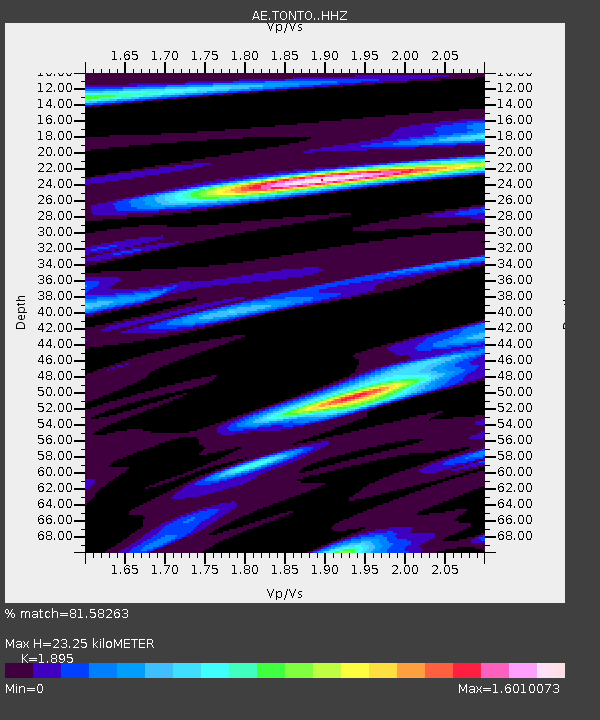
| Estimated Moho Depth: |
23.25 km |
| Estimated Crust Vp/Vs: |
1.89 |
| Assumed Crust Vp: |
6.276 km/s |
| Estimated Crust Vs: |
3.312 km/s |
| Estimated Crust Poisson's Ratio: |
0.31 |
|
| Radial Match: |
81.58263 % |
| Radial Bump: |
400 |
| Transverse Match: |
88.564445 % |
| Transverse Bump: |
400 |
| SOD ConfigId: |
30536071 |
| Insert Time: |
2023-06-04 15:47:04.334 +0000 |
| GWidth: |
2.5 |
| Max Bumps: |
400 |
| Tol: |
0.001 |
|

Signal To Noise
| Channel | StoN | STA | LTA |
| AE:TONTO: :HHZ:20230521T15:57:49.219988Z | 0.58534896 | 3.1832445E-7 | 5.4381997E-7 |
| AE:TONTO: :HHN:20230521T15:57:49.219988Z | 2.2792792 | 5.579355E-7 | 2.4478592E-7 |
| AE:TONTO: :HHE:20230521T15:57:49.219988Z | 1.2735314 | 7.410399E-7 | 5.81878E-7 |
| Arrivals |
| Ps | 3.4 SECOND |
| PpPs | 11 SECOND |
| PsPs/PpSs | 14 SECOND |


