You are here: Home > Network List > AV - Alaska Volcano Observatory Stations List
> Station ADAG Mount Adagdak, Regional Station, Alaska > Earthquake Result Viewer
ADAG Mount Adagdak, Regional Station, Alaska - Earthquake Result Viewer
| Earthquake location: |
Solomon Islands |
| Earthquake latitude/longitude: |
-10.3/161.4 |
| Earthquake time(UTC): |
2023/05/21 (141) 15:45:13 GMT |
| Earthquake Depth: |
78 km |
| Earthquake Magnitude: |
6.1 Mww |
| Earthquake Catalog/Contributor: |
NEIC PDE/us |
|
| Network: |
AV Alaska Volcano Observatory |
| Station: |
ADAG Mount Adagdak, Regional Station, Alaska |
| Lat/Lon: |
51.98 N/176.60 W |
| Elevation: |
281 m |
|
| Distance: |
64.8 deg |
| Az: |
14.803 deg |
| Baz: |
203.989 deg |
| Ray Param: |
0.058482282 |
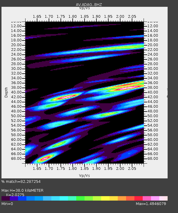
| Estimated Moho Depth: |
38.0 km |
| Estimated Crust Vp/Vs: |
2.03 |
| Assumed Crust Vp: |
5.88 km/s |
| Estimated Crust Vs: |
2.9 km/s |
| Estimated Crust Poisson's Ratio: |
0.34 |
|
| Radial Match: |
82.287254 % |
| Radial Bump: |
400 |
| Transverse Match: |
81.27467 % |
| Transverse Bump: |
400 |
| SOD ConfigId: |
30536071 |
| Insert Time: |
2023-06-04 15:49:51.363 +0000 |
| GWidth: |
2.5 |
| Max Bumps: |
400 |
| Tol: |
0.001 |
|

Signal To Noise
| Channel | StoN | STA | LTA |
| AV:ADAG: :BHZ:20230521T15:55:12.938982Z | 6.1089497 | 2.2484314E-6 | 3.6805534E-7 |
| AV:ADAG: :BHN:20230521T15:55:12.938982Z | 1.8651344 | 1.7587339E-6 | 9.4295297E-7 |
| AV:ADAG: :BHE:20230521T15:55:12.938982Z | 2.174346 | 1.7640299E-6 | 8.112922E-7 |
| Arrivals |
| Ps | 6.8 SECOND |
| PpPs | 19 SECOND |
| PsPs/PpSs | 26 SECOND |


