You are here: Home > Network List > US - United States National Seismic Network Stations List
> Station GLMI Grayling, Michigan, USA > Earthquake Result Viewer
GLMI Grayling, Michigan, USA - Earthquake Result Viewer
| Earthquake location: |
Off Coast Of Northern California |
| Earthquake latitude/longitude: |
40.4/-125.5 |
| Earthquake time(UTC): |
2023/05/21 (141) 18:44:01 GMT |
| Earthquake Depth: |
2.1 km |
| Earthquake Magnitude: |
5.6 Mww |
| Earthquake Catalog/Contributor: |
NEIC PDE/nc |
|
| Network: |
US United States National Seismic Network |
| Station: |
GLMI Grayling, Michigan, USA |
| Lat/Lon: |
44.82 N/84.62 W |
| Elevation: |
387 m |
|
| Distance: |
30.2 deg |
| Az: |
67.906 deg |
| Baz: |
276.145 deg |
| Ray Param: |
0.07950729 |
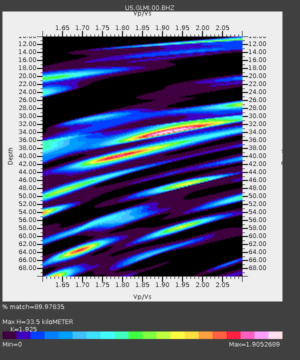
| Estimated Moho Depth: |
33.5 km |
| Estimated Crust Vp/Vs: |
1.92 |
| Assumed Crust Vp: |
6.483 km/s |
| Estimated Crust Vs: |
3.368 km/s |
| Estimated Crust Poisson's Ratio: |
0.32 |
|
| Radial Match: |
89.97835 % |
| Radial Bump: |
400 |
| Transverse Match: |
74.037476 % |
| Transverse Bump: |
400 |
| SOD ConfigId: |
30536071 |
| Insert Time: |
2023-06-04 18:57:03.216 +0000 |
| GWidth: |
2.5 |
| Max Bumps: |
400 |
| Tol: |
0.001 |
|

Signal To Noise
| Channel | StoN | STA | LTA |
| US:GLMI:00:BHZ:20230521T18:49:42.074008Z | 11.372868 | 1.8581981E-6 | 1.6338869E-7 |
| US:GLMI:00:BH1:20230521T18:49:42.074008Z | 1.920956 | 5.202262E-7 | 2.708163E-7 |
| US:GLMI:00:BH2:20230521T18:49:42.074008Z | 5.444423 | 1.8284069E-6 | 3.3583115E-7 |
| Arrivals |
| Ps | 5.2 SECOND |
| PpPs | 14 SECOND |
| PsPs/PpSs | 19 SECOND |


