You are here: Home > Network List > TA - USArray Transportable Network (new EarthScope stations) Stations List
> Station Q30A Quinter, KS, USA > Earthquake Result Viewer
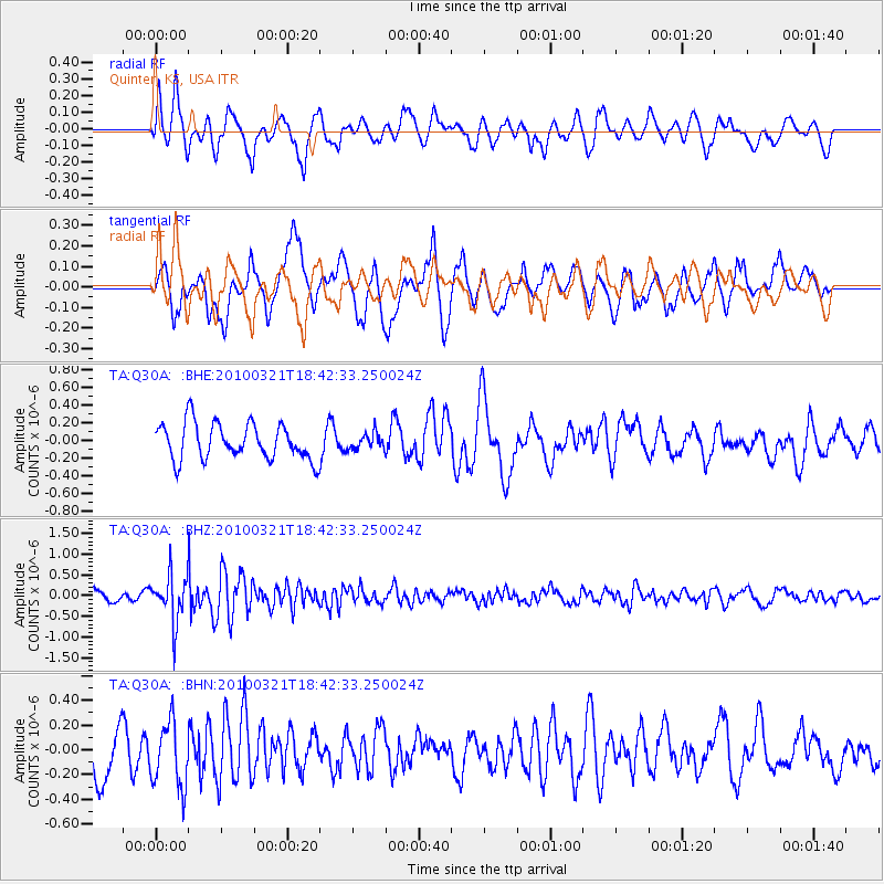
Q30A Quinter, KS, USA - Earthquake Result Viewer
*The percent match for this event was below the threshold and hence no stack was calculated.
| Earthquake location: |
Near Coast Of Central Chile |
| Earthquake latitude/longitude: |
-36.3/-73.2 |
| Earthquake time(UTC): |
2010/03/21 (080) 18:31:04 GMT |
| Earthquake Depth: |
36 km |
| Earthquake Magnitude: |
5.6 MB, 5.1 MS, 5.5 MW, 5.5 MW |
| Earthquake Catalog/Contributor: |
WHDF/NEIC |
|
| Network: |
TA USArray Transportable Network (new EarthScope stations) |
| Station: |
Q30A Quinter, KS, USA |
| Lat/Lon: |
38.98 N/100.22 W |
| Elevation: |
797 m |
|
| Distance: |
79.0 deg |
| Az: |
338.827 deg |
| Baz: |
158.03 deg |
| Ray Param: |
$rayparam |
*The percent match for this event was below the threshold and hence was not used in the summary stack. |
|
| Radial Match: |
54.42006 % |
| Radial Bump: |
400 |
| Transverse Match: |
59.881447 % |
| Transverse Bump: |
400 |
| SOD ConfigId: |
308276 |
| Insert Time: |
2010-06-22 22:27:24.784 +0000 |
| GWidth: |
2.5 |
| Max Bumps: |
400 |
| Tol: |
0.001 |
|
Signal To Noise
| Channel | StoN | STA | LTA |
| TA:Q30A: :BHZ:20100321T18:42:33.250024Z | 5.4812584 | 5.57654E-7 | 1.0173832E-7 |
| TA:Q30A: :BHN:20100321T18:42:33.250024Z | 1.0856034 | 2.5908946E-7 | 2.3865942E-7 |
| TA:Q30A: :BHE:20100321T18:42:33.250024Z | 0.4255554 | 8.645632E-8 | 2.0316112E-7 |
| Arrivals |
| Ps | |
| PpPs | |
| PsPs/PpSs | |


