You are here: Home > Network List > TA - USArray Transportable Network (new EarthScope stations) Stations List
> Station F27A Lemmon, SD, USA > Earthquake Result Viewer
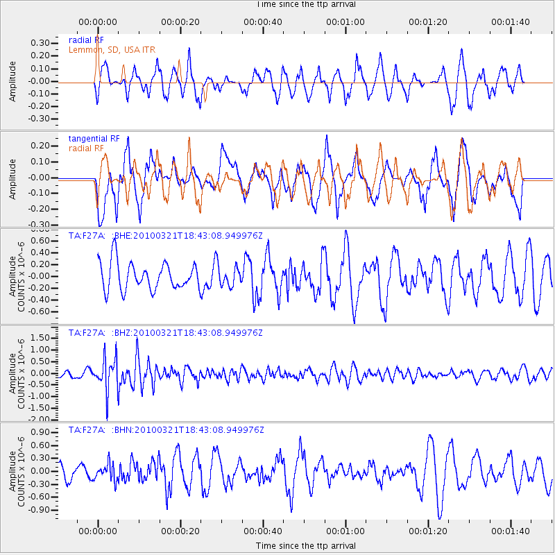
F27A Lemmon, SD, USA - Earthquake Result Viewer
*The percent match for this event was below the threshold and hence no stack was calculated.
| Earthquake location: |
Near Coast Of Central Chile |
| Earthquake latitude/longitude: |
-36.3/-73.2 |
| Earthquake time(UTC): |
2010/03/21 (080) 18:31:04 GMT |
| Earthquake Depth: |
36 km |
| Earthquake Magnitude: |
5.6 MB, 5.1 MS, 5.5 MW, 5.5 MW |
| Earthquake Catalog/Contributor: |
WHDF/NEIC |
|
| Network: |
TA USArray Transportable Network (new EarthScope stations) |
| Station: |
F27A Lemmon, SD, USA |
| Lat/Lon: |
45.87 N/102.02 W |
| Elevation: |
757 m |
|
| Distance: |
85.9 deg |
| Az: |
340.241 deg |
| Baz: |
157.005 deg |
| Ray Param: |
$rayparam |
*The percent match for this event was below the threshold and hence was not used in the summary stack. |
|
| Radial Match: |
40.784634 % |
| Radial Bump: |
300 |
| Transverse Match: |
50.061028 % |
| Transverse Bump: |
400 |
| SOD ConfigId: |
308276 |
| Insert Time: |
2010-06-22 22:30:21.522 +0000 |
| GWidth: |
2.5 |
| Max Bumps: |
400 |
| Tol: |
0.001 |
|
Signal To Noise
| Channel | StoN | STA | LTA |
| TA:F27A: :BHZ:20100321T18:43:08.949976Z | 4.1721525 | 7.167554E-7 | 1.7179511E-7 |
| TA:F27A: :BHN:20100321T18:43:08.949976Z | 0.6708047 | 1.8821044E-7 | 2.8057414E-7 |
| TA:F27A: :BHE:20100321T18:43:08.949976Z | 0.6565069 | 1.5297238E-7 | 2.3300954E-7 |
| Arrivals |
| Ps | |
| PpPs | |
| PsPs/PpSs | |


