You are here: Home > Network List > TA - USArray Transportable Network (new EarthScope stations) Stations List
> Station 134A White-Moore Ranch, Lipan, TX, USA > Earthquake Result Viewer
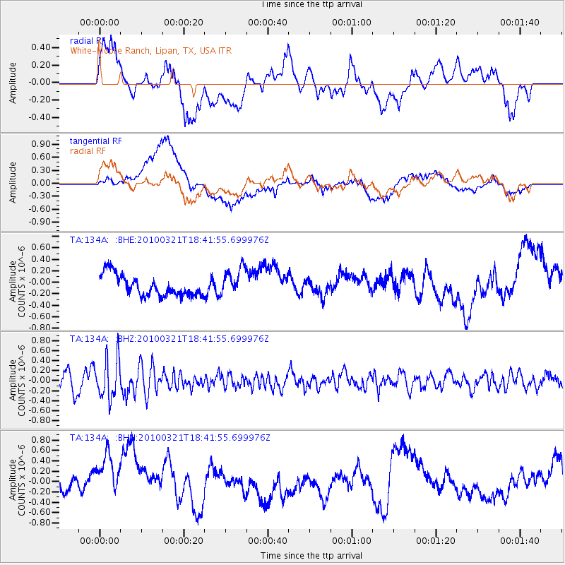
134A White-Moore Ranch, Lipan, TX, USA - Earthquake Result Viewer
*The percent match for this event was below the threshold and hence no stack was calculated.
| Earthquake location: |
Near Coast Of Central Chile |
| Earthquake latitude/longitude: |
-36.3/-73.2 |
| Earthquake time(UTC): |
2010/03/21 (080) 18:31:04 GMT |
| Earthquake Depth: |
36 km |
| Earthquake Magnitude: |
5.6 MB, 5.1 MS, 5.5 MW, 5.5 MW |
| Earthquake Catalog/Contributor: |
WHDF/NEIC |
|
| Network: |
TA USArray Transportable Network (new EarthScope stations) |
| Station: |
134A White-Moore Ranch, Lipan, TX, USA |
| Lat/Lon: |
32.57 N/98.08 W |
| Elevation: |
297 m |
|
| Distance: |
72.4 deg |
| Az: |
338.091 deg |
| Baz: |
159.096 deg |
| Ray Param: |
$rayparam |
*The percent match for this event was below the threshold and hence was not used in the summary stack. |
|
| Radial Match: |
36.83534 % |
| Radial Bump: |
400 |
| Transverse Match: |
44.72549 % |
| Transverse Bump: |
400 |
| SOD ConfigId: |
308276 |
| Insert Time: |
2010-06-22 22:37:24.464 +0000 |
| GWidth: |
2.5 |
| Max Bumps: |
400 |
| Tol: |
0.001 |
|
Signal To Noise
| Channel | StoN | STA | LTA |
| TA:134A: :BHZ:20100321T18:41:55.699976Z | 2.4163306 | 4.0129123E-7 | 1.6607464E-7 |
| TA:134A: :BHN:20100321T18:41:55.699976Z | 2.560826 | 6.4306914E-7 | 2.5111785E-7 |
| TA:134A: :BHE:20100321T18:41:55.699976Z | 1.4031165 | 2.5474307E-7 | 1.815552E-7 |
| Arrivals |
| Ps | |
| PpPs | |
| PsPs/PpSs | |


