You are here: Home > Network List > US - United States National Seismic Network Stations List
> Station ERPA Erie, Pennsylvania, USA > Earthquake Result Viewer
ERPA Erie, Pennsylvania, USA - Earthquake Result Viewer
*The percent match for this event was below the threshold and hence no stack was calculated.
| Earthquake location: |
Near Coast Of Central Chile |
| Earthquake latitude/longitude: |
-36.3/-73.2 |
| Earthquake time(UTC): |
2010/03/21 (080) 18:31:04 GMT |
| Earthquake Depth: |
36 km |
| Earthquake Magnitude: |
5.6 MB, 5.1 MS, 5.5 MW, 5.5 MW |
| Earthquake Catalog/Contributor: |
WHDF/NEIC |
|
| Network: |
US United States National Seismic Network |
| Station: |
ERPA Erie, Pennsylvania, USA |
| Lat/Lon: |
42.12 N/79.99 W |
| Elevation: |
306 m |
|
| Distance: |
78.3 deg |
| Az: |
354.82 deg |
| Baz: |
174.378 deg |
| Ray Param: |
$rayparam |
*The percent match for this event was below the threshold and hence was not used in the summary stack. |
|
| Radial Match: |
43.86713 % |
| Radial Bump: |
400 |
| Transverse Match: |
30.104595 % |
| Transverse Bump: |
400 |
| SOD ConfigId: |
308276 |
| Insert Time: |
2010-06-22 22:40:42.795 +0000 |
| GWidth: |
2.5 |
| Max Bumps: |
400 |
| Tol: |
0.001 |
|
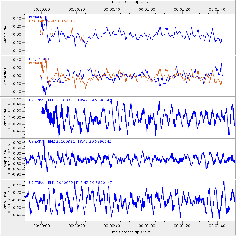
Signal To Noise
| Channel | StoN | STA | LTA |
| US:ERPA: :BHZ:20100321T18:42:29.589014Z | 2.8501022 | 4.3650678E-7 | 1.5315479E-7 |
| US:ERPA: :BHN:20100321T18:42:29.589014Z | 0.9096241 | 1.642554E-7 | 1.8057504E-7 |
| US:ERPA: :BHE:20100321T18:42:29.589014Z | 0.5898972 | 1.3639729E-7 | 2.3122215E-7 |
| Arrivals |
| Ps | |
| PpPs | |
| PsPs/PpSs | |


