You are here: Home > Network List > US - United States National Seismic Network Stations List
> Station AGMN Agassiz National Wildlife Refuge, Minnesota, USA > Earthquake Result Viewer
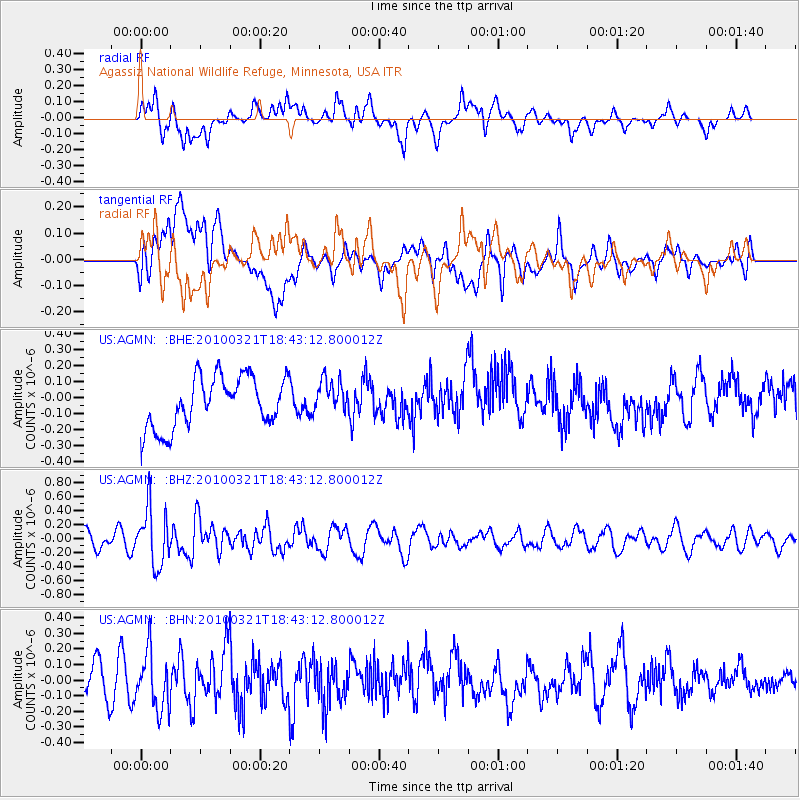
AGMN Agassiz National Wildlife Refuge, Minnesota, USA - Earthquake Result Viewer
*The percent match for this event was below the threshold and hence no stack was calculated.
| Earthquake location: |
Near Coast Of Central Chile |
| Earthquake latitude/longitude: |
-36.3/-73.2 |
| Earthquake time(UTC): |
2010/03/21 (080) 18:31:04 GMT |
| Earthquake Depth: |
36 km |
| Earthquake Magnitude: |
5.6 MB, 5.1 MS, 5.5 MW, 5.5 MW |
| Earthquake Catalog/Contributor: |
WHDF/NEIC |
|
| Network: |
US United States National Seismic Network |
| Station: |
AGMN Agassiz National Wildlife Refuge, Minnesota, USA |
| Lat/Lon: |
48.30 N/95.86 W |
| Elevation: |
351 m |
|
| Distance: |
86.7 deg |
| Az: |
345.043 deg |
| Baz: |
161.816 deg |
| Ray Param: |
$rayparam |
*The percent match for this event was below the threshold and hence was not used in the summary stack. |
|
| Radial Match: |
49.885925 % |
| Radial Bump: |
400 |
| Transverse Match: |
35.272278 % |
| Transverse Bump: |
400 |
| SOD ConfigId: |
308276 |
| Insert Time: |
2010-06-22 22:41:25.152 +0000 |
| GWidth: |
2.5 |
| Max Bumps: |
400 |
| Tol: |
0.001 |
|
Signal To Noise
| Channel | StoN | STA | LTA |
| US:AGMN: :BHZ:20100321T18:43:12.800012Z | 2.644977 | 4.0134566E-7 | 1.517388E-7 |
| US:AGMN: :BHN:20100321T18:43:12.800012Z | 1.6532892 | 1.8473598E-7 | 1.1173846E-7 |
| US:AGMN: :BHE:20100321T18:43:12.800012Z | 0.6719994 | 1.06201455E-7 | 1.5803802E-7 |
| Arrivals |
| Ps | |
| PpPs | |
| PsPs/PpSs | |


