You are here: Home > Network List > US - United States National Seismic Network Stations List
> Station HAWA Hanford, Washington, USA > Earthquake Result Viewer
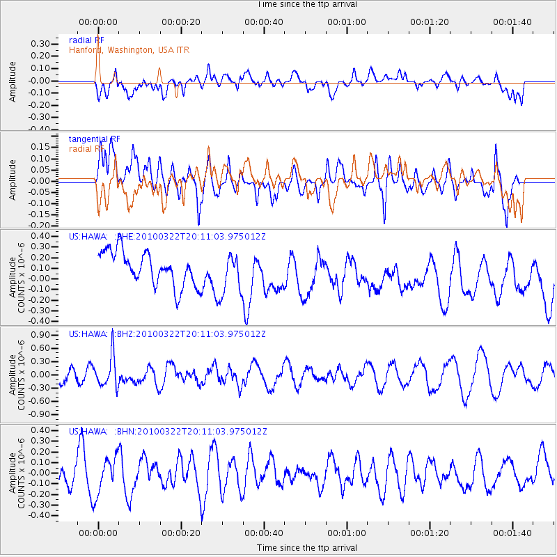
HAWA Hanford, Washington, USA - Earthquake Result Viewer
*The percent match for this event was below the threshold and hence no stack was calculated.
| Earthquake location: |
Luzon, Philippines |
| Earthquake latitude/longitude: |
18.5/120.7 |
| Earthquake time(UTC): |
2010/03/22 (081) 19:58:14 GMT |
| Earthquake Depth: |
48 km |
| Earthquake Magnitude: |
5.8 MB, 5.4 MS, 5.9 MW, 5.8 MW |
| Earthquake Catalog/Contributor: |
WHDF/NEIC |
|
| Network: |
US United States National Seismic Network |
| Station: |
HAWA Hanford, Washington, USA |
| Lat/Lon: |
46.39 N/119.53 W |
| Elevation: |
364 m |
|
| Distance: |
95.7 deg |
| Az: |
37.154 deg |
| Baz: |
304.084 deg |
| Ray Param: |
$rayparam |
*The percent match for this event was below the threshold and hence was not used in the summary stack. |
|
| Radial Match: |
58.54464 % |
| Radial Bump: |
400 |
| Transverse Match: |
54.574375 % |
| Transverse Bump: |
400 |
| SOD ConfigId: |
308276 |
| Insert Time: |
2010-06-22 22:51:05.260 +0000 |
| GWidth: |
2.5 |
| Max Bumps: |
400 |
| Tol: |
0.001 |
|
Signal To Noise
| Channel | StoN | STA | LTA |
| US:HAWA: :BHZ:20100322T20:11:03.975012Z | 1.6160591 | 3.5850772E-7 | 2.2184074E-7 |
| US:HAWA: :BHN:20100322T20:11:03.975012Z | 1.137547 | 1.6487972E-7 | 1.4494321E-7 |
| US:HAWA: :BHE:20100322T20:11:03.975012Z | 1.2182785 | 1.9418236E-7 | 1.5939077E-7 |
| Arrivals |
| Ps | |
| PpPs | |
| PsPs/PpSs | |


