You are here: Home > Network List > UW - Pacific Northwest Regional Seismic Network Stations List
> Station MRBL Marblemount, WA, USA > Earthquake Result Viewer
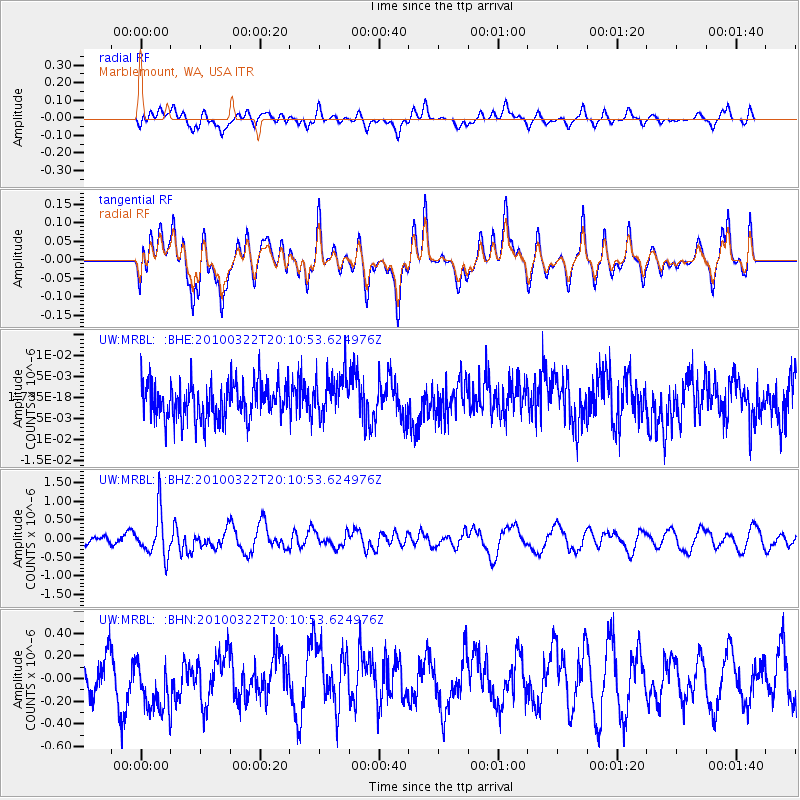
MRBL Marblemount, WA, USA - Earthquake Result Viewer
*The percent match for this event was below the threshold and hence no stack was calculated.
| Earthquake location: |
Luzon, Philippines |
| Earthquake latitude/longitude: |
18.5/120.7 |
| Earthquake time(UTC): |
2010/03/22 (081) 19:58:14 GMT |
| Earthquake Depth: |
48 km |
| Earthquake Magnitude: |
5.8 MB, 5.4 MS, 5.9 MW, 5.8 MW |
| Earthquake Catalog/Contributor: |
WHDF/NEIC |
|
| Network: |
UW Pacific Northwest Regional Seismic Network |
| Station: |
MRBL Marblemount, WA, USA |
| Lat/Lon: |
48.52 N/121.48 W |
| Elevation: |
75 m |
|
| Distance: |
93.4 deg |
| Az: |
36.105 deg |
| Baz: |
302.733 deg |
| Ray Param: |
$rayparam |
*The percent match for this event was below the threshold and hence was not used in the summary stack. |
|
| Radial Match: |
48.5739 % |
| Radial Bump: |
400 |
| Transverse Match: |
48.962402 % |
| Transverse Bump: |
400 |
| SOD ConfigId: |
308276 |
| Insert Time: |
2010-06-22 22:51:51.399 +0000 |
| GWidth: |
2.5 |
| Max Bumps: |
400 |
| Tol: |
0.001 |
|
Signal To Noise
| Channel | StoN | STA | LTA |
| UW:MRBL: :BHZ:20100322T20:10:53.624976Z | 4.06284 | 5.834447E-7 | 1.4360515E-7 |
| UW:MRBL: :BHN:20100322T20:10:53.624976Z | 1.4849594 | 2.8533717E-7 | 1.921515E-7 |
| UW:MRBL: :BHE:20100322T20:10:53.624976Z | 1.1742666 | 5.073686E-9 | 4.3207273E-9 |
| Arrivals |
| Ps | |
| PpPs | |
| PsPs/PpSs | |


