You are here: Home > Network List > II - Global Seismograph Network (GSN - IRIS/IDA) Stations List
> Station PALK Pallekele, Sri Lanka > Earthquake Result Viewer
PALK Pallekele, Sri Lanka - Earthquake Result Viewer
| Earthquake location: |
Banda Sea |
| Earthquake latitude/longitude: |
-7.0/129.5 |
| Earthquake time(UTC): |
2023/05/24 (144) 15:49:34 GMT |
| Earthquake Depth: |
166 km |
| Earthquake Magnitude: |
6.2 Mww |
| Earthquake Catalog/Contributor: |
NEIC PDE/us |
|
| Network: |
II Global Seismograph Network (GSN - IRIS/IDA) |
| Station: |
PALK Pallekele, Sri Lanka |
| Lat/Lon: |
7.27 N/80.70 E |
| Elevation: |
460 m |
|
| Distance: |
50.7 deg |
| Az: |
285.259 deg |
| Baz: |
105.127 deg |
| Ray Param: |
0.06730203 |
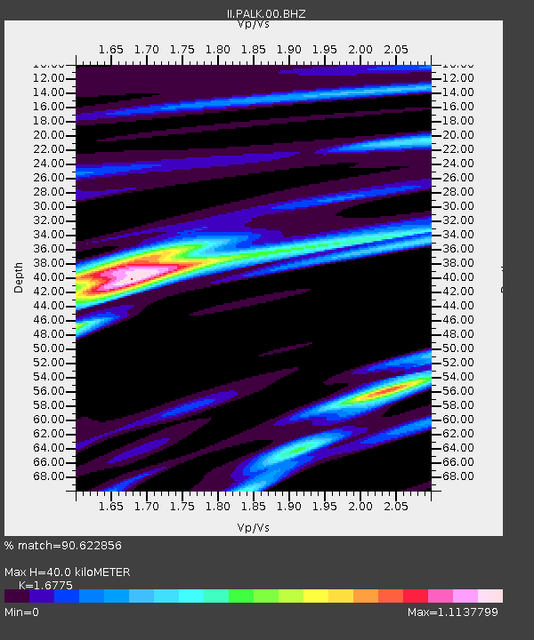
| Estimated Moho Depth: |
40.0 km |
| Estimated Crust Vp/Vs: |
1.68 |
| Assumed Crust Vp: |
6.545 km/s |
| Estimated Crust Vs: |
3.902 km/s |
| Estimated Crust Poisson's Ratio: |
0.22 |
|
| Radial Match: |
90.622856 % |
| Radial Bump: |
273 |
| Transverse Match: |
75.9231 % |
| Transverse Bump: |
400 |
| SOD ConfigId: |
30536071 |
| Insert Time: |
2023-06-07 15:58:30.237 +0000 |
| GWidth: |
2.5 |
| Max Bumps: |
400 |
| Tol: |
0.001 |
|
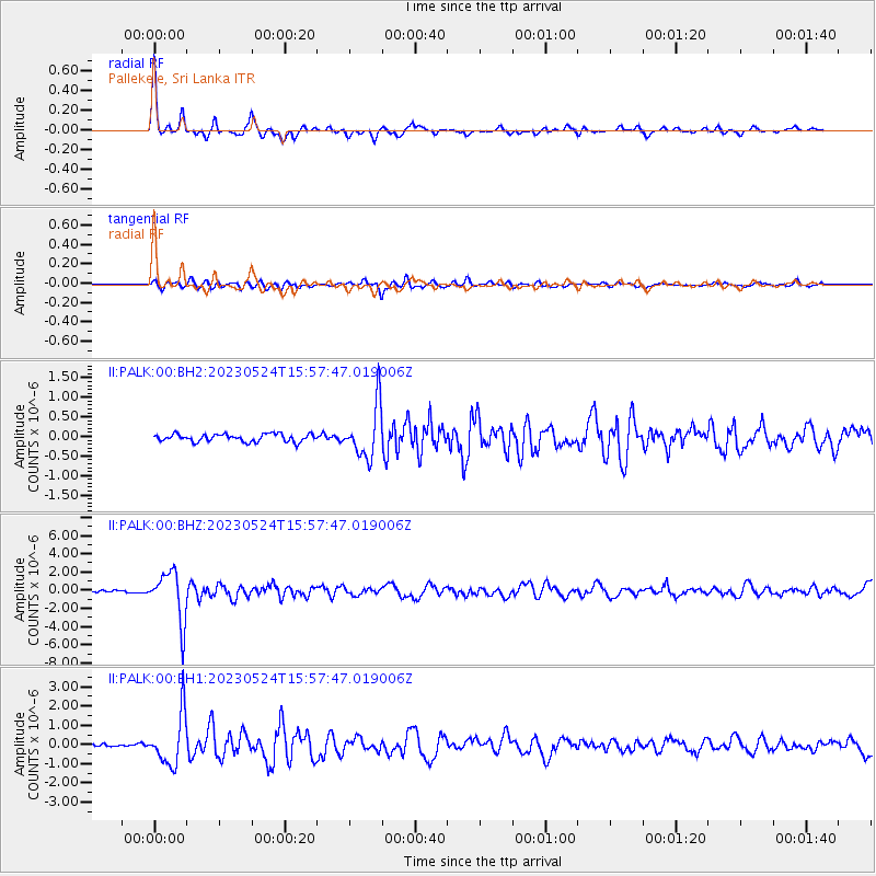
Signal To Noise
| Channel | StoN | STA | LTA |
| II:PALK:00:BHZ:20230524T15:57:47.019006Z | 23.48576 | 2.7555025E-6 | 1.17326515E-7 |
| II:PALK:00:BH1:20230524T15:57:47.019006Z | 18.00655 | 1.3158773E-6 | 7.30777E-8 |
| II:PALK:00:BH2:20230524T15:57:47.019006Z | 6.8717895 | 6.712167E-7 | 9.767714E-8 |
| Arrivals |
| Ps | 4.4 SECOND |
| PpPs | 15 SECOND |
| PsPs/PpSs | 20 SECOND |


