You are here: Home > Network List > IU - Global Seismograph Network (GSN - IRIS/USGS) Stations List
> Station ULN Ulaanbaatar, Mongolia > Earthquake Result Viewer
ULN Ulaanbaatar, Mongolia - Earthquake Result Viewer
| Earthquake location: |
Banda Sea |
| Earthquake latitude/longitude: |
-7.0/129.5 |
| Earthquake time(UTC): |
2023/05/24 (144) 15:49:34 GMT |
| Earthquake Depth: |
166 km |
| Earthquake Magnitude: |
6.2 Mww |
| Earthquake Catalog/Contributor: |
NEIC PDE/us |
|
| Network: |
IU Global Seismograph Network (GSN - IRIS/USGS) |
| Station: |
ULN Ulaanbaatar, Mongolia |
| Lat/Lon: |
47.87 N/107.05 E |
| Elevation: |
1610 m |
|
| Distance: |
58.1 deg |
| Az: |
342.35 deg |
| Baz: |
153.45 deg |
| Ray Param: |
0.06253174 |
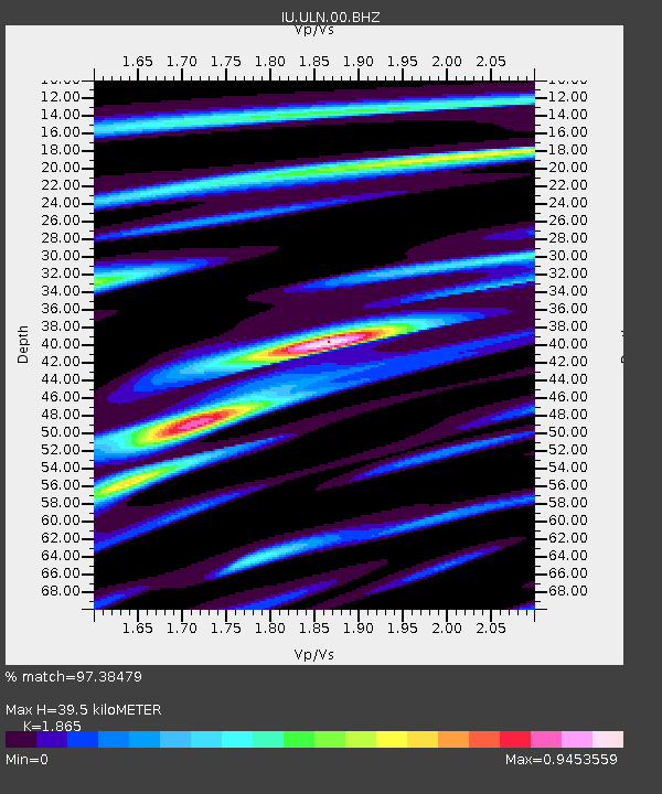
| Estimated Moho Depth: |
39.5 km |
| Estimated Crust Vp/Vs: |
1.87 |
| Assumed Crust Vp: |
6.642 km/s |
| Estimated Crust Vs: |
3.561 km/s |
| Estimated Crust Poisson's Ratio: |
0.30 |
|
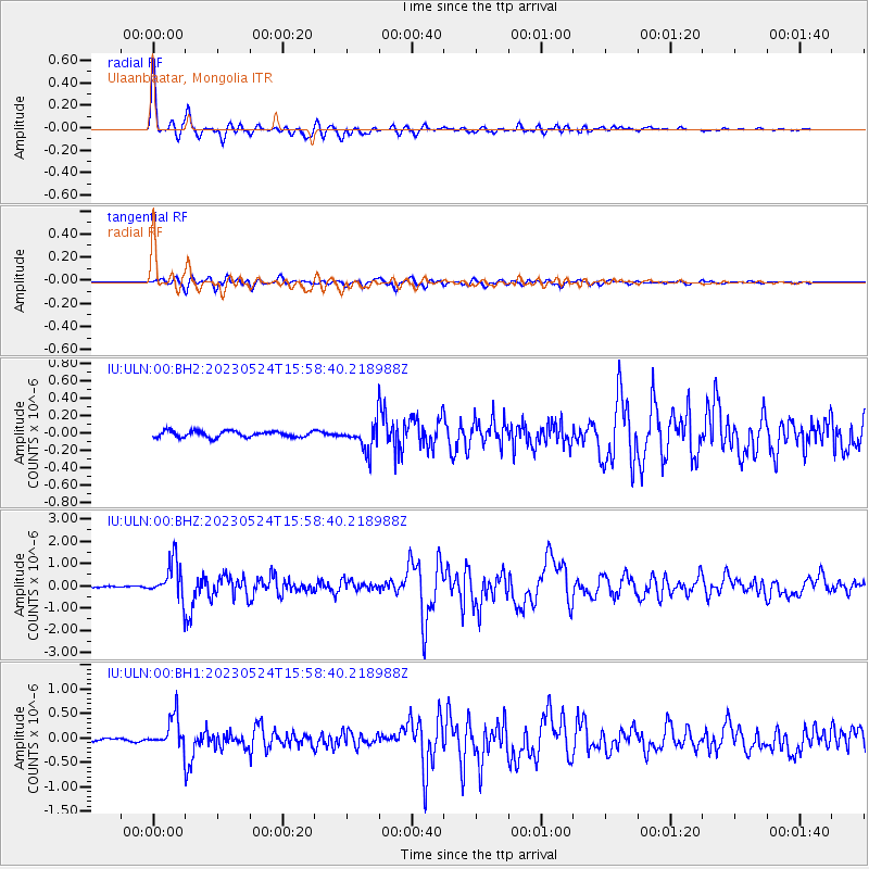
| Radial Match: |
97.38479 % |
| Radial Bump: |
342 |
| Transverse Match: |
91.00587 % |
| Transverse Bump: |
400 |
| SOD ConfigId: |
30536071 |
| Insert Time: |
2023-06-07 15:59:01.833 +0000 |
| GWidth: |
2.5 |
| Max Bumps: |
400 |
| Tol: |
0.001 |
|
Signal To Noise
| Channel | StoN | STA | LTA |
| IU:ULN:00:BHZ:20230524T15:58:40.218988Z | 19.60929 | 8.5316606E-7 | 4.3508262E-8 |
| IU:ULN:00:BH1:20230524T15:58:40.218988Z | 12.202616 | 3.2208243E-7 | 2.639454E-8 |
| IU:ULN:00:BH2:20230524T15:58:40.218988Z | 4.34033 | 1.5084684E-7 | 3.475469E-8 |
| Arrivals |
| Ps | 5.4 SECOND |
| PpPs | 16 SECOND |
| PsPs/PpSs | 22 SECOND |


