You are here: Home > Network List > TM - Thai Seismic Monitoring Network Stations List
> Station SURA Don Sak, Surat Thani > Earthquake Result Viewer
SURA Don Sak, Surat Thani - Earthquake Result Viewer
| Earthquake location: |
Banda Sea |
| Earthquake latitude/longitude: |
-7.0/129.5 |
| Earthquake time(UTC): |
2023/05/24 (144) 15:49:34 GMT |
| Earthquake Depth: |
166 km |
| Earthquake Magnitude: |
6.2 Mww |
| Earthquake Catalog/Contributor: |
NEIC PDE/us |
|
| Network: |
TM Thai Seismic Monitoring Network |
| Station: |
SURA Don Sak, Surat Thani |
| Lat/Lon: |
9.17 N/99.63 E |
| Elevation: |
18 m |
|
| Distance: |
33.8 deg |
| Az: |
297.888 deg |
| Baz: |
117.303 deg |
| Ray Param: |
0.0774833 |
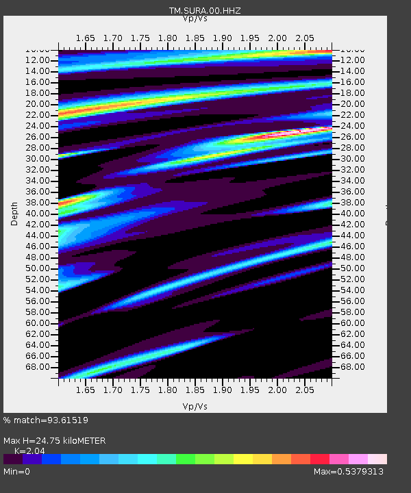
| Estimated Moho Depth: |
24.75 km |
| Estimated Crust Vp/Vs: |
2.04 |
| Assumed Crust Vp: |
6.468 km/s |
| Estimated Crust Vs: |
3.17 km/s |
| Estimated Crust Poisson's Ratio: |
0.34 |
|
| Radial Match: |
93.61519 % |
| Radial Bump: |
135 |
| Transverse Match: |
67.721 % |
| Transverse Bump: |
400 |
| SOD ConfigId: |
30536071 |
| Insert Time: |
2023-06-07 16:01:40.283 +0000 |
| GWidth: |
2.5 |
| Max Bumps: |
400 |
| Tol: |
0.001 |
|

Signal To Noise
| Channel | StoN | STA | LTA |
| TM:SURA:00:HHZ:20230524T15:55:31.059991Z | 23.8971 | 2.6830255E-6 | 1.122741E-7 |
| TM:SURA:00:HHN:20230524T15:55:31.059991Z | 3.0959938 | 6.343552E-7 | 2.0489551E-7 |
| TM:SURA:00:HHE:20230524T15:55:31.059991Z | 15.150761 | 1.3138746E-6 | 8.6720036E-8 |
| Arrivals |
| Ps | 4.3 SECOND |
| PpPs | 11 SECOND |
| PsPs/PpSs | 15 SECOND |


