You are here: Home > Network List > AK - Alaska Regional Network Stations List
> Station L16K Owhat River, AK, USA > Earthquake Result Viewer
L16K Owhat River, AK, USA - Earthquake Result Viewer
| Earthquake location: |
Panama-Colombia Border Region |
| Earthquake latitude/longitude: |
8.9/-77.1 |
| Earthquake time(UTC): |
2023/05/25 (145) 03:05:34 GMT |
| Earthquake Depth: |
10 km |
| Earthquake Magnitude: |
6.6 Mi |
| Earthquake Catalog/Contributor: |
NEIC PDE/at |
|
| Network: |
AK Alaska Regional Network |
| Station: |
L16K Owhat River, AK, USA |
| Lat/Lon: |
61.71 N/159.47 W |
| Elevation: |
227 m |
|
| Distance: |
78.6 deg |
| Az: |
331.205 deg |
| Baz: |
92.459 deg |
| Ray Param: |
0.049528945 |
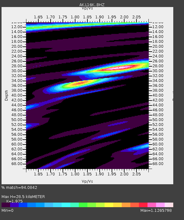
| Estimated Moho Depth: |
28.5 km |
| Estimated Crust Vp/Vs: |
1.98 |
| Assumed Crust Vp: |
6.276 km/s |
| Estimated Crust Vs: |
3.178 km/s |
| Estimated Crust Poisson's Ratio: |
0.33 |
|
| Radial Match: |
94.0842 % |
| Radial Bump: |
296 |
| Transverse Match: |
80.04604 % |
| Transverse Bump: |
289 |
| SOD ConfigId: |
30536071 |
| Insert Time: |
2023-06-08 03:09:57.135 +0000 |
| GWidth: |
2.5 |
| Max Bumps: |
400 |
| Tol: |
0.001 |
|

Signal To Noise
| Channel | StoN | STA | LTA |
| AK:L16K: :BHZ:20230525T03:17:04.419983Z | 17.294025 | 1.7054035E-6 | 9.86123E-8 |
| AK:L16K: :BHN:20230525T03:17:04.419983Z | 1.4427867 | 1.549558E-7 | 1.0740035E-7 |
| AK:L16K: :BHE:20230525T03:17:04.419983Z | 8.194414 | 7.1280203E-7 | 8.6986326E-8 |
| Arrivals |
| Ps | 4.5 SECOND |
| PpPs | 13 SECOND |
| PsPs/PpSs | 18 SECOND |


