You are here: Home > Network List > AK - Alaska Regional Network Stations List
> Station P17K Kvichak River, AK, USA > Earthquake Result Viewer
P17K Kvichak River, AK, USA - Earthquake Result Viewer
| Earthquake location: |
Panama-Colombia Border Region |
| Earthquake latitude/longitude: |
8.9/-77.1 |
| Earthquake time(UTC): |
2023/05/25 (145) 03:05:34 GMT |
| Earthquake Depth: |
10 km |
| Earthquake Magnitude: |
6.6 Mi |
| Earthquake Catalog/Contributor: |
NEIC PDE/at |
|
| Network: |
AK Alaska Regional Network |
| Station: |
P17K Kvichak River, AK, USA |
| Lat/Lon: |
59.20 N/156.44 W |
| Elevation: |
91 m |
|
| Distance: |
76.9 deg |
| Az: |
328.722 deg |
| Baz: |
94.57 deg |
| Ray Param: |
0.050653286 |
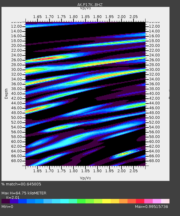
| Estimated Moho Depth: |
64.75 km |
| Estimated Crust Vp/Vs: |
2.01 |
| Assumed Crust Vp: |
6.276 km/s |
| Estimated Crust Vs: |
3.122 km/s |
| Estimated Crust Poisson's Ratio: |
0.34 |
|
| Radial Match: |
80.645805 % |
| Radial Bump: |
400 |
| Transverse Match: |
68.76917 % |
| Transverse Bump: |
400 |
| SOD ConfigId: |
30536071 |
| Insert Time: |
2023-06-08 03:10:35.069 +0000 |
| GWidth: |
2.5 |
| Max Bumps: |
400 |
| Tol: |
0.001 |
|

Signal To Noise
| Channel | StoN | STA | LTA |
| AK:P17K: :BHZ:20230525T03:16:55.219971Z | 8.370183 | 1.7277919E-6 | 2.0642224E-7 |
| AK:P17K: :BHN:20230525T03:16:55.219971Z | 1.033596 | 3.927261E-7 | 3.7996094E-7 |
| AK:P17K: :BHE:20230525T03:16:55.219971Z | 2.6368756 | 1.2294204E-6 | 4.6624132E-7 |
| Arrivals |
| Ps | 11 SECOND |
| PpPs | 30 SECOND |
| PsPs/PpSs | 41 SECOND |


