You are here: Home > Network List > US - United States National Seismic Network Stations List
> Station HAWA Hanford, Washington, USA > Earthquake Result Viewer
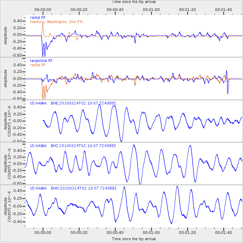
HAWA Hanford, Washington, USA - Earthquake Result Viewer
*The percent match for this event was below the threshold and hence no stack was calculated.
| Earthquake location: |
Xizang |
| Earthquake latitude/longitude: |
32.5/92.7 |
| Earthquake time(UTC): |
2010/03/24 (083) 02:06:10 GMT |
| Earthquake Depth: |
5.0 km |
| Earthquake Magnitude: |
5.6 MB, 5.5 MS, 5.7 MW, 5.5 MW |
| Earthquake Catalog/Contributor: |
WHDF/NEIC |
|
| Network: |
US United States National Seismic Network |
| Station: |
HAWA Hanford, Washington, USA |
| Lat/Lon: |
46.39 N/119.53 W |
| Elevation: |
364 m |
|
| Distance: |
96.2 deg |
| Az: |
21.802 deg |
| Baz: |
333.039 deg |
| Ray Param: |
$rayparam |
*The percent match for this event was below the threshold and hence was not used in the summary stack. |
|
| Radial Match: |
63.27775 % |
| Radial Bump: |
400 |
| Transverse Match: |
46.533115 % |
| Transverse Bump: |
400 |
| SOD ConfigId: |
308276 |
| Insert Time: |
2010-06-22 22:57:17.051 +0000 |
| GWidth: |
2.5 |
| Max Bumps: |
400 |
| Tol: |
0.001 |
|
Signal To Noise
| Channel | StoN | STA | LTA |
| US:HAWA: :BHZ:20100324T02:19:07.724988Z | 0.2285133 | 9.091722E-8 | 3.9786403E-7 |
| US:HAWA: :BHN:20100324T02:19:07.724988Z | 0.7125164 | 1.3798542E-7 | 1.9365929E-7 |
| US:HAWA: :BHE:20100324T02:19:07.724988Z | 1.7448391 | 3.0795064E-7 | 1.7649228E-7 |
| Arrivals |
| Ps | |
| PpPs | |
| PsPs/PpSs | |


