You are here: Home > Network List > AV - Alaska Volcano Observatory Stations List
> Station MGLS Mageik Landslide, Katmai, Volcanic Group, Alaska > Earthquake Result Viewer
MGLS Mageik Landslide, Katmai, Volcanic Group, Alaska - Earthquake Result Viewer
| Earthquake location: |
Panama-Colombia Border Region |
| Earthquake latitude/longitude: |
8.9/-77.1 |
| Earthquake time(UTC): |
2023/05/25 (145) 03:05:34 GMT |
| Earthquake Depth: |
10 km |
| Earthquake Magnitude: |
6.6 Mi |
| Earthquake Catalog/Contributor: |
NEIC PDE/at |
|
| Network: |
AV Alaska Volcano Observatory |
| Station: |
MGLS Mageik Landslide, Katmai, Volcanic Group, Alaska |
| Lat/Lon: |
58.13 N/155.16 W |
| Elevation: |
472 m |
|
| Distance: |
76.2 deg |
| Az: |
327.691 deg |
| Baz: |
95.419 deg |
| Ray Param: |
0.05116126 |
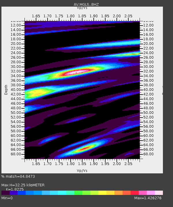
| Estimated Moho Depth: |
32.25 km |
| Estimated Crust Vp/Vs: |
1.82 |
| Assumed Crust Vp: |
6.438 km/s |
| Estimated Crust Vs: |
3.533 km/s |
| Estimated Crust Poisson's Ratio: |
0.28 |
|
| Radial Match: |
84.8473 % |
| Radial Bump: |
400 |
| Transverse Match: |
65.59562 % |
| Transverse Bump: |
400 |
| SOD ConfigId: |
30536071 |
| Insert Time: |
2023-06-08 03:13:35.468 +0000 |
| GWidth: |
2.5 |
| Max Bumps: |
400 |
| Tol: |
0.001 |
|

Signal To Noise
| Channel | StoN | STA | LTA |
| AV:MGLS: :BHZ:20230525T03:16:50.958984Z | 6.5816092 | 1.3428253E-6 | 2.0402688E-7 |
| AV:MGLS: :BHN:20230525T03:16:50.958984Z | 0.9485139 | 4.003096E-7 | 4.2203874E-7 |
| AV:MGLS: :BHE:20230525T03:16:50.958984Z | 2.3577156 | 9.628725E-7 | 4.0839214E-7 |
| Arrivals |
| Ps | 4.2 SECOND |
| PpPs | 14 SECOND |
| PsPs/PpSs | 18 SECOND |


