You are here: Home > Network List > AV - Alaska Volcano Observatory Stations List
> Station N20K Mount Spurr, AK, USA > Earthquake Result Viewer
N20K Mount Spurr, AK, USA - Earthquake Result Viewer
| Earthquake location: |
Panama-Colombia Border Region |
| Earthquake latitude/longitude: |
8.9/-77.1 |
| Earthquake time(UTC): |
2023/05/25 (145) 03:05:34 GMT |
| Earthquake Depth: |
10 km |
| Earthquake Magnitude: |
6.6 Mi |
| Earthquake Catalog/Contributor: |
NEIC PDE/at |
|
| Network: |
AV Alaska Volcano Observatory |
| Station: |
N20K Mount Spurr, AK, USA |
| Lat/Lon: |
61.20 N/152.21 W |
| Elevation: |
991 m |
|
| Distance: |
75.1 deg |
| Az: |
331.033 deg |
| Baz: |
98.795 deg |
| Ray Param: |
0.051908545 |
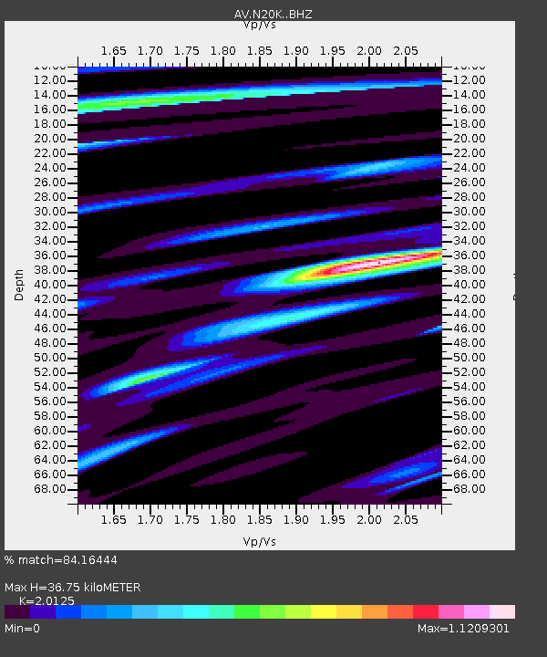
| Estimated Moho Depth: |
36.75 km |
| Estimated Crust Vp/Vs: |
2.01 |
| Assumed Crust Vp: |
6.566 km/s |
| Estimated Crust Vs: |
3.263 km/s |
| Estimated Crust Poisson's Ratio: |
0.34 |
|
| Radial Match: |
84.16444 % |
| Radial Bump: |
400 |
| Transverse Match: |
86.873055 % |
| Transverse Bump: |
400 |
| SOD ConfigId: |
30536071 |
| Insert Time: |
2023-06-08 03:13:44.780 +0000 |
| GWidth: |
2.5 |
| Max Bumps: |
400 |
| Tol: |
0.001 |
|

Signal To Noise
| Channel | StoN | STA | LTA |
| AV:N20K: :BHZ:20230525T03:16:44.625Z | 14.510127 | 1.6636252E-6 | 1.146527E-7 |
| AV:N20K: :BHN:20230525T03:16:44.625Z | 2.6386273 | 2.4838172E-7 | 9.4132936E-8 |
| AV:N20K: :BHE:20230525T03:16:44.625Z | 6.600184 | 6.908665E-7 | 1.0467382E-7 |
| Arrivals |
| Ps | 5.8 SECOND |
| PpPs | 16 SECOND |
| PsPs/PpSs | 22 SECOND |


