You are here: Home > Network List > GM - US Geological Survey Networks Stations List
> Station NMP44 New Mexico Permian - Site# W4S4 > Earthquake Result Viewer
NMP44 New Mexico Permian - Site# W4S4 - Earthquake Result Viewer
| Earthquake location: |
Panama-Colombia Border Region |
| Earthquake latitude/longitude: |
8.9/-77.1 |
| Earthquake time(UTC): |
2023/05/25 (145) 03:05:34 GMT |
| Earthquake Depth: |
10 km |
| Earthquake Magnitude: |
6.6 Mi |
| Earthquake Catalog/Contributor: |
NEIC PDE/at |
|
| Network: |
GM US Geological Survey Networks |
| Station: |
NMP44 New Mexico Permian - Site# W4S4 |
| Lat/Lon: |
32.20 N/103.62 W |
| Elevation: |
1086 m |
|
| Distance: |
33.8 deg |
| Az: |
317.111 deg |
| Baz: |
127.509 deg |
| Ray Param: |
0.07806075 |
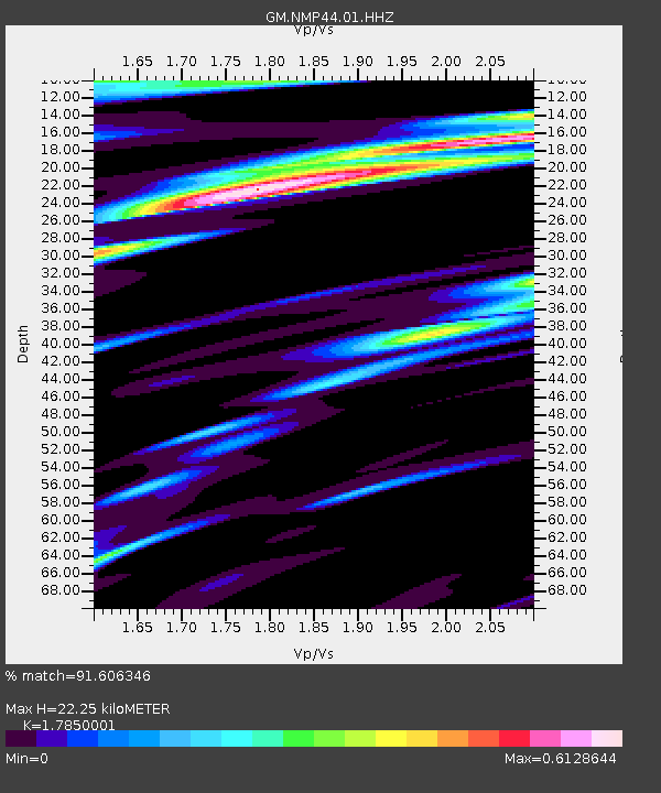
| Estimated Moho Depth: |
22.25 km |
| Estimated Crust Vp/Vs: |
1.79 |
| Assumed Crust Vp: |
6.129 km/s |
| Estimated Crust Vs: |
3.434 km/s |
| Estimated Crust Poisson's Ratio: |
0.27 |
|
| Radial Match: |
91.606346 % |
| Radial Bump: |
301 |
| Transverse Match: |
62.28174 % |
| Transverse Bump: |
400 |
| SOD ConfigId: |
30536071 |
| Insert Time: |
2023-06-08 03:26:28.460 +0000 |
| GWidth: |
2.5 |
| Max Bumps: |
400 |
| Tol: |
0.001 |
|

Signal To Noise
| Channel | StoN | STA | LTA |
| GM:NMP44:01:HHZ:20230525T03:11:45.250Z | 8.305567 | 1.7913853E-6 | 2.1568489E-7 |
| GM:NMP44:01:HHN:20230525T03:11:45.250Z | 2.5593557 | 5.338251E-7 | 2.085779E-7 |
| GM:NMP44:01:HHE:20230525T03:11:45.250Z | 5.746376 | 9.378975E-7 | 1.6321547E-7 |
| Arrivals |
| Ps | 3.1 SECOND |
| PpPs | 9.4 SECOND |
| PsPs/PpSs | 12 SECOND |


