You are here: Home > Network List > GS - US Geological Survey Networks Stations List
> Station MCA04 MCA04, Monte Cristo Range, NV > Earthquake Result Viewer
MCA04 MCA04, Monte Cristo Range, NV - Earthquake Result Viewer
| Earthquake location: |
Panama-Colombia Border Region |
| Earthquake latitude/longitude: |
8.9/-77.1 |
| Earthquake time(UTC): |
2023/05/25 (145) 03:05:34 GMT |
| Earthquake Depth: |
10 km |
| Earthquake Magnitude: |
6.6 Mi |
| Earthquake Catalog/Contributor: |
NEIC PDE/at |
|
| Network: |
GS US Geological Survey Networks |
| Station: |
MCA04 MCA04, Monte Cristo Range, NV |
| Lat/Lon: |
38.08 N/117.71 W |
| Elevation: |
1662 m |
|
| Distance: |
46.7 deg |
| Az: |
315.061 deg |
| Baz: |
117.822 deg |
| Ray Param: |
0.07051243 |
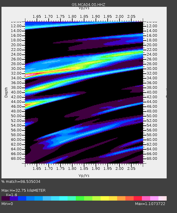
| Estimated Moho Depth: |
32.75 km |
| Estimated Crust Vp/Vs: |
1.60 |
| Assumed Crust Vp: |
6.276 km/s |
| Estimated Crust Vs: |
3.922 km/s |
| Estimated Crust Poisson's Ratio: |
0.18 |
|
| Radial Match: |
86.535034 % |
| Radial Bump: |
395 |
| Transverse Match: |
71.98362 % |
| Transverse Bump: |
400 |
| SOD ConfigId: |
30536071 |
| Insert Time: |
2023-06-08 03:26:57.176 +0000 |
| GWidth: |
2.5 |
| Max Bumps: |
400 |
| Tol: |
0.001 |
|

Signal To Noise
| Channel | StoN | STA | LTA |
| GS:MCA04:00:HHZ:20230525T03:13:31.600006Z | 9.941107 | 1.870958E-6 | 1.882042E-7 |
| GS:MCA04:00:HH1:20230525T03:13:31.600006Z | 3.4124339 | 4.770455E-7 | 1.3979626E-7 |
| GS:MCA04:00:HH2:20230525T03:13:31.600006Z | 3.8670282 | 1.0219795E-6 | 2.6428035E-7 |
| Arrivals |
| Ps | 3.3 SECOND |
| PpPs | 13 SECOND |
| PsPs/PpSs | 16 SECOND |


