You are here: Home > Network List > LD - Lamont-Doherty Cooperative Seismographic Network Stations List
> Station GEDE Greenville, DE, USA > Earthquake Result Viewer
GEDE Greenville, DE, USA - Earthquake Result Viewer
| Earthquake location: |
Panama-Colombia Border Region |
| Earthquake latitude/longitude: |
8.9/-77.1 |
| Earthquake time(UTC): |
2023/05/25 (145) 03:05:34 GMT |
| Earthquake Depth: |
10 km |
| Earthquake Magnitude: |
6.6 Mi |
| Earthquake Catalog/Contributor: |
NEIC PDE/at |
|
| Network: |
LD Lamont-Doherty Cooperative Seismographic Network |
| Station: |
GEDE Greenville, DE, USA |
| Lat/Lon: |
39.81 N/75.64 W |
| Elevation: |
105 m |
|
| Distance: |
30.8 deg |
| Az: |
2.202 deg |
| Baz: |
182.826 deg |
| Ray Param: |
0.07930338 |
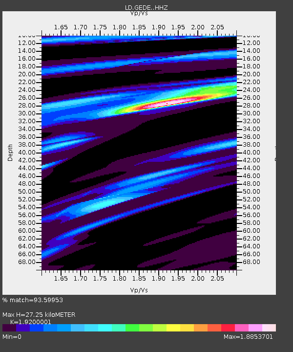
| Estimated Moho Depth: |
27.25 km |
| Estimated Crust Vp/Vs: |
1.92 |
| Assumed Crust Vp: |
6.287 km/s |
| Estimated Crust Vs: |
3.275 km/s |
| Estimated Crust Poisson's Ratio: |
0.31 |
|
| Radial Match: |
93.59953 % |
| Radial Bump: |
180 |
| Transverse Match: |
63.128593 % |
| Transverse Bump: |
400 |
| SOD ConfigId: |
30536071 |
| Insert Time: |
2023-06-08 03:28:58.469 +0000 |
| GWidth: |
2.5 |
| Max Bumps: |
400 |
| Tol: |
0.001 |
|

Signal To Noise
| Channel | StoN | STA | LTA |
| LD:GEDE: :HHZ:20230525T03:11:19.179993Z | 27.79271 | 3.5495239E-6 | 1.277142E-7 |
| LD:GEDE: :HHN:20230525T03:11:19.179993Z | 21.771276 | 2.4658486E-6 | 1.13261564E-7 |
| LD:GEDE: :HHE:20230525T03:11:19.179993Z | 0.6904607 | 1.039703E-7 | 1.5058104E-7 |
| Arrivals |
| Ps | 4.3 SECOND |
| PpPs | 12 SECOND |
| PsPs/PpSs | 16 SECOND |


