You are here: Home > Network List > N4 - Central and EAstern US Network Stations List
> Station I37B Waseca, MN, USA > Earthquake Result Viewer
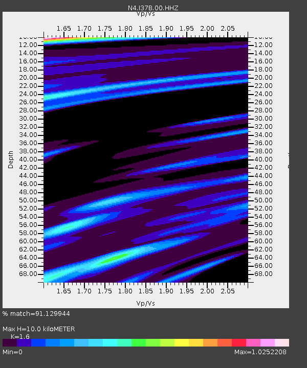
I37B Waseca, MN, USA - Earthquake Result Viewer
| Earthquake location: |
Panama-Colombia Border Region |
| Earthquake latitude/longitude: |
8.9/-77.1 |
| Earthquake time(UTC): |
2023/05/25 (145) 03:05:34 GMT |
| Earthquake Depth: |
10 km |
| Earthquake Magnitude: |
6.6 Mi |
| Earthquake Catalog/Contributor: |
NEIC PDE/at |
|
| Network: |
N4 Central and EAstern US Network |
| Station: |
I37B Waseca, MN, USA |
| Lat/Lon: |
44.01 N/93.40 W |
| Elevation: |
354 m |
|
| Distance: |
37.8 deg |
| Az: |
340.685 deg |
| Baz: |
153.064 deg |
| Ray Param: |
0.07596363 |
| Estimated Moho Depth: |
10.0 km |
| Estimated Crust Vp/Vs: |
1.60 |
| Assumed Crust Vp: |
6.571 km/s |
| Estimated Crust Vs: |
4.107 km/s |
| Estimated Crust Poisson's Ratio: |
0.18 |
|
| Radial Match: |
91.129944 % |
| Radial Bump: |
395 |
| Transverse Match: |
63.949585 % |
| Transverse Bump: |
400 |
| SOD ConfigId: |
30536071 |
| Insert Time: |
2023-06-08 03:30:13.418 +0000 |
| GWidth: |
2.5 |
| Max Bumps: |
400 |
| Tol: |
0.001 |
|

Signal To Noise
| Channel | StoN | STA | LTA |
| N4:I37B:00:HHZ:20230525T03:12:19.140015Z | 15.257568 | 3.8653693E-6 | 2.5334114E-7 |
| N4:I37B:00:HH1:20230525T03:12:19.140015Z | 5.529417 | 2.0841749E-6 | 3.7692487E-7 |
| N4:I37B:00:HH2:20230525T03:12:19.140015Z | 3.1575391 | 8.103798E-7 | 2.5664917E-7 |
| Arrivals |
| Ps | 1.0 SECOND |
| PpPs | 3.6 SECOND |
| PsPs/PpSs | 4.6 SECOND |


