You are here: Home > Network List > O2 - Oklahoma Consolidated Temporary Seismic Networks Stations List
> Station PERK Perkins, Oklahoma, USA > Earthquake Result Viewer
PERK Perkins, Oklahoma, USA - Earthquake Result Viewer
| Earthquake location: |
Panama-Colombia Border Region |
| Earthquake latitude/longitude: |
8.9/-77.1 |
| Earthquake time(UTC): |
2023/05/25 (145) 03:05:34 GMT |
| Earthquake Depth: |
10 km |
| Earthquake Magnitude: |
6.6 Mi |
| Earthquake Catalog/Contributor: |
NEIC PDE/at |
|
| Network: |
O2 Oklahoma Consolidated Temporary Seismic Networks |
| Station: |
PERK Perkins, Oklahoma, USA |
| Lat/Lon: |
35.93 N/97.13 W |
| Elevation: |
288 m |
|
| Distance: |
32.5 deg |
| Az: |
328.855 deg |
| Baz: |
140.975 deg |
| Ray Param: |
0.07863255 |
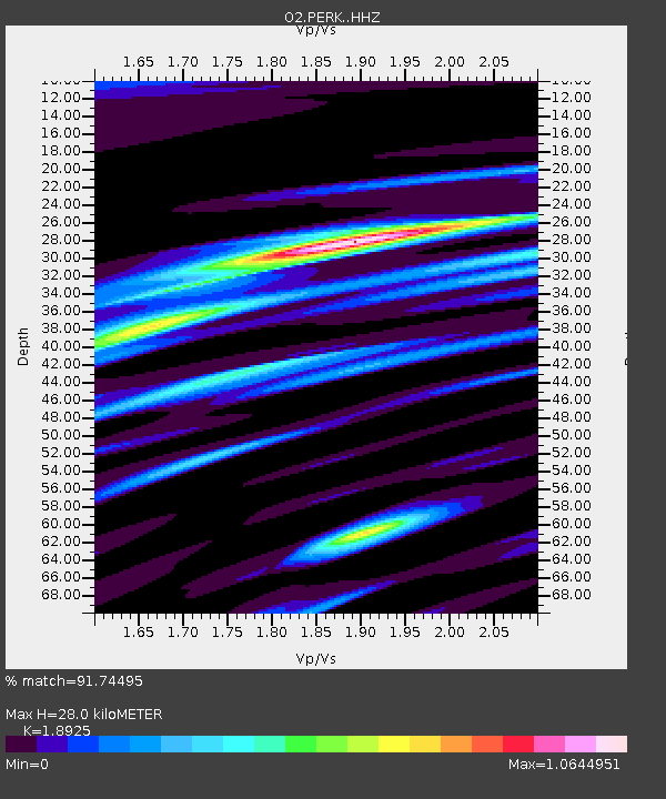
| Estimated Moho Depth: |
28.0 km |
| Estimated Crust Vp/Vs: |
1.89 |
| Assumed Crust Vp: |
6.426 km/s |
| Estimated Crust Vs: |
3.396 km/s |
| Estimated Crust Poisson's Ratio: |
0.31 |
|
| Radial Match: |
91.74495 % |
| Radial Bump: |
263 |
| Transverse Match: |
69.59678 % |
| Transverse Bump: |
400 |
| SOD ConfigId: |
30536071 |
| Insert Time: |
2023-06-08 03:34:16.588 +0000 |
| GWidth: |
2.5 |
| Max Bumps: |
400 |
| Tol: |
0.001 |
|

Signal To Noise
| Channel | StoN | STA | LTA |
| O2:PERK: :HHZ:20230525T03:11:34.125Z | 31.000898 | 3.6690399E-6 | 1.18352695E-7 |
| O2:PERK: :HHN:20230525T03:11:34.125Z | 8.875878 | 2.379904E-6 | 2.6813163E-7 |
| O2:PERK: :HHE:20230525T03:11:34.125Z | 16.132597 | 1.9452996E-6 | 1.2058193E-7 |
| Arrivals |
| Ps | 4.2 SECOND |
| PpPs | 12 SECOND |
| PsPs/PpSs | 16 SECOND |


