You are here: Home > Network List > O2 - Oklahoma Consolidated Temporary Seismic Networks Stations List
> Station PW15 Ralston, Oklahoma, USA > Earthquake Result Viewer
PW15 Ralston, Oklahoma, USA - Earthquake Result Viewer
| Earthquake location: |
Panama-Colombia Border Region |
| Earthquake latitude/longitude: |
8.9/-77.1 |
| Earthquake time(UTC): |
2023/05/25 (145) 03:05:34 GMT |
| Earthquake Depth: |
10 km |
| Earthquake Magnitude: |
6.6 Mi |
| Earthquake Catalog/Contributor: |
NEIC PDE/at |
|
| Network: |
O2 Oklahoma Consolidated Temporary Seismic Networks |
| Station: |
PW15 Ralston, Oklahoma, USA |
| Lat/Lon: |
36.47 N/97.01 W |
| Elevation: |
270 m |
|
| Distance: |
32.9 deg |
| Az: |
329.617 deg |
| Baz: |
141.684 deg |
| Ray Param: |
0.07846618 |
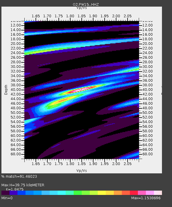
| Estimated Moho Depth: |
39.75 km |
| Estimated Crust Vp/Vs: |
1.85 |
| Assumed Crust Vp: |
6.483 km/s |
| Estimated Crust Vs: |
3.509 km/s |
| Estimated Crust Poisson's Ratio: |
0.29 |
|
| Radial Match: |
91.46023 % |
| Radial Bump: |
215 |
| Transverse Match: |
70.161446 % |
| Transverse Bump: |
400 |
| SOD ConfigId: |
30536071 |
| Insert Time: |
2023-06-08 03:34:31.268 +0000 |
| GWidth: |
2.5 |
| Max Bumps: |
400 |
| Tol: |
0.001 |
|

Signal To Noise
| Channel | StoN | STA | LTA |
| O2:PW15: :HHZ:20230525T03:11:37.299988Z | 27.629908 | 4.195766E-6 | 1.5185594E-7 |
| O2:PW15: :HHN:20230525T03:11:37.299988Z | 27.208164 | 2.288479E-6 | 8.411001E-8 |
| O2:PW15: :HHE:20230525T03:11:37.299988Z | 18.313444 | 1.99345E-6 | 1.0885173E-7 |
| Arrivals |
| Ps | 5.6 SECOND |
| PpPs | 16 SECOND |
| PsPs/PpSs | 22 SECOND |


