You are here: Home > Network List > O2 - Oklahoma Consolidated Temporary Seismic Networks Stations List
> Station STIG Stigler, Oklahoma, USA > Earthquake Result Viewer
STIG Stigler, Oklahoma, USA - Earthquake Result Viewer
| Earthquake location: |
Panama-Colombia Border Region |
| Earthquake latitude/longitude: |
8.9/-77.1 |
| Earthquake time(UTC): |
2023/05/25 (145) 03:05:34 GMT |
| Earthquake Depth: |
10 km |
| Earthquake Magnitude: |
6.6 Mi |
| Earthquake Catalog/Contributor: |
NEIC PDE/at |
|
| Network: |
O2 Oklahoma Consolidated Temporary Seismic Networks |
| Station: |
STIG Stigler, Oklahoma, USA |
| Lat/Lon: |
35.34 N/95.11 W |
| Elevation: |
256 m |
|
| Distance: |
31.0 deg |
| Az: |
330.655 deg |
| Baz: |
143.679 deg |
| Ray Param: |
0.07922231 |
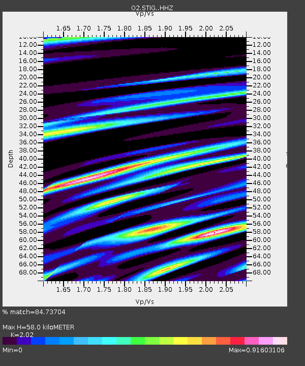
| Estimated Moho Depth: |
58.0 km |
| Estimated Crust Vp/Vs: |
2.02 |
| Assumed Crust Vp: |
6.498 km/s |
| Estimated Crust Vs: |
3.217 km/s |
| Estimated Crust Poisson's Ratio: |
0.34 |
|
| Radial Match: |
84.73704 % |
| Radial Bump: |
400 |
| Transverse Match: |
67.26781 % |
| Transverse Bump: |
400 |
| SOD ConfigId: |
30536071 |
| Insert Time: |
2023-06-08 03:35:16.995 +0000 |
| GWidth: |
2.5 |
| Max Bumps: |
400 |
| Tol: |
0.001 |
|

Signal To Noise
| Channel | StoN | STA | LTA |
| O2:STIG: :HHZ:20230525T03:11:21.234985Z | 29.90297 | 3.4637903E-6 | 1.15834325E-7 |
| O2:STIG: :HHN:20230525T03:11:21.234985Z | 12.991489 | 1.5813928E-6 | 1.217253E-7 |
| O2:STIG: :HHE:20230525T03:11:21.234985Z | 16.029917 | 1.6259613E-6 | 1.0143292E-7 |
| Arrivals |
| Ps | 9.8 SECOND |
| PpPs | 25 SECOND |
| PsPs/PpSs | 35 SECOND |


