You are here: Home > Network List > US - United States National Seismic Network Stations List
> Station MSO Missoula, Montana, USA > Earthquake Result Viewer
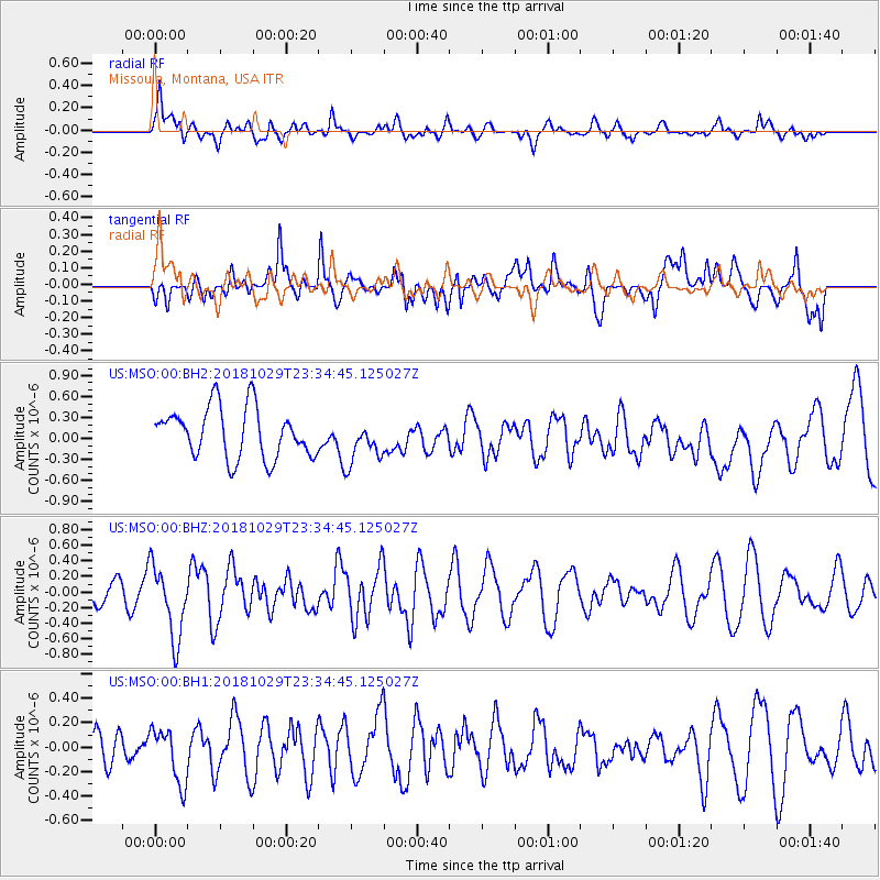
MSO Missoula, Montana, USA - Earthquake Result Viewer
*The percent match for this event was below the threshold and hence no stack was calculated.
| Earthquake location: |
Central East Pacific Rise |
| Earthquake latitude/longitude: |
-4.6/-105.9 |
| Earthquake time(UTC): |
2018/10/29 (302) 23:26:09 GMT |
| Earthquake Depth: |
10 km |
| Earthquake Magnitude: |
5.8 Mww |
| Earthquake Catalog/Contributor: |
NEIC PDE/us |
|
| Network: |
US United States National Seismic Network |
| Station: |
MSO Missoula, Montana, USA |
| Lat/Lon: |
46.83 N/113.94 W |
| Elevation: |
1264 m |
|
| Distance: |
51.7 deg |
| Az: |
352.976 deg |
| Baz: |
169.774 deg |
| Ray Param: |
$rayparam |
*The percent match for this event was below the threshold and hence was not used in the summary stack. |
|
| Radial Match: |
62.5604 % |
| Radial Bump: |
400 |
| Transverse Match: |
45.431343 % |
| Transverse Bump: |
400 |
| SOD ConfigId: |
3103472 |
| Insert Time: |
2018-11-12 23:33:00.980 +0000 |
| GWidth: |
2.5 |
| Max Bumps: |
400 |
| Tol: |
0.001 |
|
Signal To Noise
| Channel | StoN | STA | LTA |
| US:MSO:00:BHZ:20181029T23:34:45.125027Z | 3.801165 | 4.6277492E-7 | 1.2174554E-7 |
| US:MSO:00:BH1:20181029T23:34:45.125027Z | 1.3371419 | 2.2143102E-7 | 1.6560026E-7 |
| US:MSO:00:BH2:20181029T23:34:45.125027Z | 0.87497485 | 3.1330978E-7 | 3.580786E-7 |
| Arrivals |
| Ps | |
| PpPs | |
| PsPs/PpSs | |


