You are here: Home > Network List > US - United States National Seismic Network Stations List
> Station OGNE Ogallala, Nebraska, USA > Earthquake Result Viewer
OGNE Ogallala, Nebraska, USA - Earthquake Result Viewer

| Earthquake location: |
Panama-Colombia Border Region |
| Earthquake latitude/longitude: |
8.9/-77.1 |
| Earthquake time(UTC): |
2023/05/25 (145) 03:05:34 GMT |
| Earthquake Depth: |
10 km |
| Earthquake Magnitude: |
6.6 Mi |
| Earthquake Catalog/Contributor: |
NEIC PDE/at |
|
| Network: |
US United States National Seismic Network |
| Station: |
OGNE Ogallala, Nebraska, USA |
| Lat/Lon: |
40.95 N/102.03 W |
| Elevation: |
1054 m |
|
| Distance: |
38.8 deg |
| Az: |
329.378 deg |
| Baz: |
138.36 deg |
| Ray Param: |
0.075367376 |
| Estimated Moho Depth: |
16.25 km |
| Estimated Crust Vp/Vs: |
1.61 |
| Assumed Crust Vp: |
6.483 km/s |
| Estimated Crust Vs: |
4.033 km/s |
| Estimated Crust Poisson's Ratio: |
0.18 |
|
| Radial Match: |
95.49046 % |
| Radial Bump: |
216 |
| Transverse Match: |
60.281326 % |
| Transverse Bump: |
324 |
| SOD ConfigId: |
30536071 |
| Insert Time: |
2023-06-08 03:43:47.838 +0000 |
| GWidth: |
2.5 |
| Max Bumps: |
400 |
| Tol: |
0.001 |
|
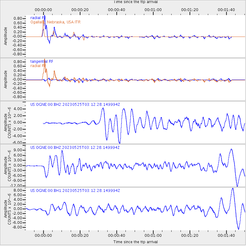
Signal To Noise
| Channel | StoN | STA | LTA |
| US:OGNE:00:BHZ:20230525T03:12:28.149994Z | 33.464397 | 3.8702087E-6 | 1.1565153E-7 |
| US:OGNE:00:BH1:20230525T03:12:28.149994Z | 5.988938 | 1.4503723E-6 | 2.4217522E-7 |
| US:OGNE:00:BH2:20230525T03:12:28.149994Z | 18.581789 | 2.759461E-6 | 1.4850352E-7 |
| Arrivals |
| Ps | 1.7 SECOND |
| PpPs | 6.0 SECOND |
| PsPs/PpSs | 7.7 SECOND |


