You are here: Home > Network List > US - United States National Seismic Network Stations List
> Station WVOR Wild Horse Valley, Oregon, USA > Earthquake Result Viewer
WVOR Wild Horse Valley, Oregon, USA - Earthquake Result Viewer
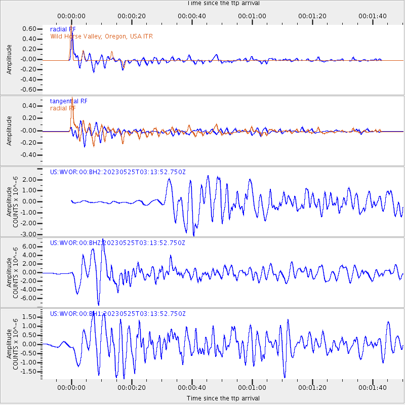
| Earthquake location: |
Panama-Colombia Border Region |
| Earthquake latitude/longitude: |
8.9/-77.1 |
| Earthquake time(UTC): |
2023/05/25 (145) 03:05:34 GMT |
| Earthquake Depth: |
10 km |
| Earthquake Magnitude: |
6.6 Mi |
| Earthquake Catalog/Contributor: |
NEIC PDE/at |
|
| Network: |
US United States National Seismic Network |
| Station: |
WVOR Wild Horse Valley, Oregon, USA |
| Lat/Lon: |
42.43 N/118.64 W |
| Elevation: |
1344 m |
|
| Distance: |
49.4 deg |
| Az: |
319.713 deg |
| Baz: |
120.337 deg |
| Ray Param: |
0.06874605 |
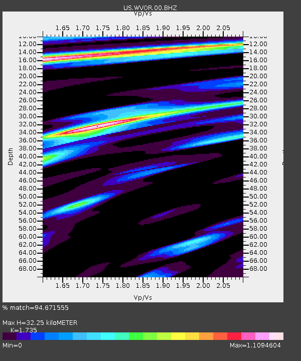
| Estimated Moho Depth: |
32.25 km |
| Estimated Crust Vp/Vs: |
1.74 |
| Assumed Crust Vp: |
6.279 km/s |
| Estimated Crust Vs: |
3.619 km/s |
| Estimated Crust Poisson's Ratio: |
0.25 |
|
| Radial Match: |
94.671555 % |
| Radial Bump: |
355 |
| Transverse Match: |
89.47372 % |
| Transverse Bump: |
400 |
| SOD ConfigId: |
30536071 |
| Insert Time: |
2023-06-08 03:44:01.750 +0000 |
| GWidth: |
2.5 |
| Max Bumps: |
400 |
| Tol: |
0.001 |
|
Signal To Noise
| Channel | StoN | STA | LTA |
| US:WVOR:00:BHZ:20230525T03:13:52.750Z | 32.23148 | 2.6056202E-6 | 8.084084E-8 |
| US:WVOR:00:BH1:20230525T03:13:52.750Z | 7.5274625 | 6.688686E-7 | 8.8857114E-8 |
| US:WVOR:00:BH2:20230525T03:13:52.750Z | 13.4124365 | 1.1936347E-6 | 8.8994625E-8 |
| Arrivals |
| Ps | 4.0 SECOND |
| PpPs | 13 SECOND |
| PsPs/PpSs | 17 SECOND |


