You are here: Home > Network List > UU - University of Utah Regional Network Stations List
> Station CCUT Cedar City, UT, USA > Earthquake Result Viewer
CCUT Cedar City, UT, USA - Earthquake Result Viewer
| Earthquake location: |
Panama-Colombia Border Region |
| Earthquake latitude/longitude: |
8.9/-77.1 |
| Earthquake time(UTC): |
2023/05/25 (145) 03:05:34 GMT |
| Earthquake Depth: |
10 km |
| Earthquake Magnitude: |
6.6 Mi |
| Earthquake Catalog/Contributor: |
NEIC PDE/at |
|
| Network: |
UU University of Utah Regional Network |
| Station: |
CCUT Cedar City, UT, USA |
| Lat/Lon: |
37.55 N/113.36 W |
| Elevation: |
2127 m |
|
| Distance: |
43.4 deg |
| Az: |
316.832 deg |
| Baz: |
121.728 deg |
| Ray Param: |
0.07257544 |
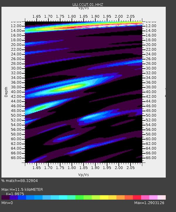
| Estimated Moho Depth: |
11.5 km |
| Estimated Crust Vp/Vs: |
2.00 |
| Assumed Crust Vp: |
6.194 km/s |
| Estimated Crust Vs: |
3.101 km/s |
| Estimated Crust Poisson's Ratio: |
0.33 |
|
| Radial Match: |
88.32904 % |
| Radial Bump: |
306 |
| Transverse Match: |
62.97668 % |
| Transverse Bump: |
353 |
| SOD ConfigId: |
30536071 |
| Insert Time: |
2023-06-08 03:44:04.790 +0000 |
| GWidth: |
2.5 |
| Max Bumps: |
400 |
| Tol: |
0.001 |
|

Signal To Noise
| Channel | StoN | STA | LTA |
| UU:CCUT:01:HHZ:20230525T03:13:05.799988Z | 13.408638 | 2.081439E-6 | 1.5523122E-7 |
| UU:CCUT:01:HHN:20230525T03:13:05.799988Z | 4.278751 | 6.203751E-7 | 1.4498977E-7 |
| UU:CCUT:01:HHE:20230525T03:13:05.799988Z | 4.7569785 | 1.0438335E-6 | 2.1943205E-7 |
| Arrivals |
| Ps | 2.0 SECOND |
| PpPs | 5.3 SECOND |
| PsPs/PpSs | 7.2 SECOND |


