You are here: Home > Network List > UW - Pacific Northwest Regional Seismic Network Stations List
> Station HERD Green Diamond Tree Farm, Grays Harbor County, WA, USA > Earthquake Result Viewer
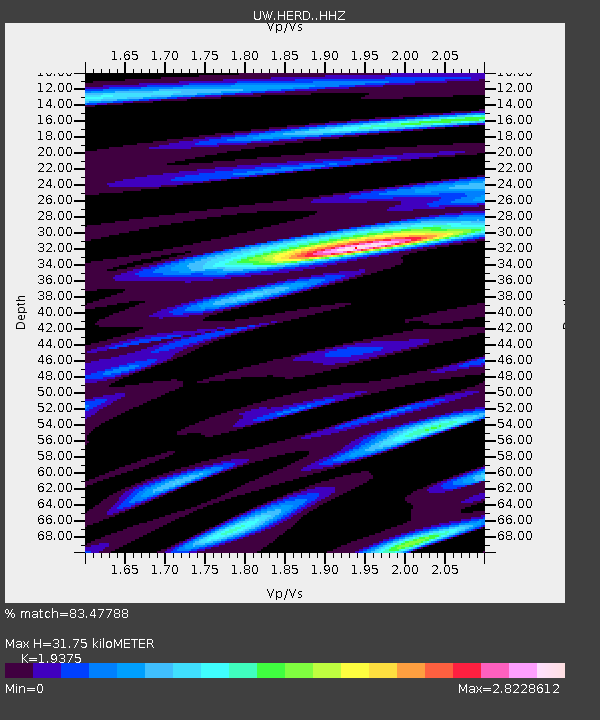
HERD Green Diamond Tree Farm, Grays Harbor County, WA, USA - Earthquake Result Viewer
| Earthquake location: |
Panama-Colombia Border Region |
| Earthquake latitude/longitude: |
8.9/-77.1 |
| Earthquake time(UTC): |
2023/05/25 (145) 03:05:34 GMT |
| Earthquake Depth: |
10 km |
| Earthquake Magnitude: |
6.6 Mi |
| Earthquake Catalog/Contributor: |
NEIC PDE/at |
|
| Network: |
UW Pacific Northwest Regional Seismic Network |
| Station: |
HERD Green Diamond Tree Farm, Grays Harbor County, WA, USA |
| Lat/Lon: |
47.23 N/123.65 W |
| Elevation: |
178 m |
|
| Distance: |
54.9 deg |
| Az: |
322.764 deg |
| Baz: |
118.684 deg |
| Ray Param: |
0.06518298 |
| Estimated Moho Depth: |
31.75 km |
| Estimated Crust Vp/Vs: |
1.94 |
| Assumed Crust Vp: |
6.566 km/s |
| Estimated Crust Vs: |
3.389 km/s |
| Estimated Crust Poisson's Ratio: |
0.32 |
|
| Radial Match: |
83.47788 % |
| Radial Bump: |
400 |
| Transverse Match: |
74.312744 % |
| Transverse Bump: |
400 |
| SOD ConfigId: |
30536071 |
| Insert Time: |
2023-06-08 03:46:01.131 +0000 |
| GWidth: |
2.5 |
| Max Bumps: |
400 |
| Tol: |
0.001 |
|

Signal To Noise
| Channel | StoN | STA | LTA |
| UW:HERD: :HHZ:20230525T03:14:33.359985Z | 21.94286 | 3.2937319E-6 | 1.5010495E-7 |
| UW:HERD: :HHN:20230525T03:14:33.359985Z | 2.0520325 | 6.158153E-7 | 3.0010017E-7 |
| UW:HERD: :HHE:20230525T03:14:33.359985Z | 4.673091 | 1.4815025E-6 | 3.170284E-7 |
| Arrivals |
| Ps | 4.8 SECOND |
| PpPs | 14 SECOND |
| PsPs/PpSs | 18 SECOND |


