You are here: Home > Network List > UW - Pacific Northwest Regional Seismic Network Stations List
> Station HOOD Mt Hood Meadows, OR CREST BB SMO > Earthquake Result Viewer
HOOD Mt Hood Meadows, OR CREST BB SMO - Earthquake Result Viewer
| Earthquake location: |
Panama-Colombia Border Region |
| Earthquake latitude/longitude: |
8.9/-77.1 |
| Earthquake time(UTC): |
2023/05/25 (145) 03:05:34 GMT |
| Earthquake Depth: |
10 km |
| Earthquake Magnitude: |
6.6 Mi |
| Earthquake Catalog/Contributor: |
NEIC PDE/at |
|
| Network: |
UW Pacific Northwest Regional Seismic Network |
| Station: |
HOOD Mt Hood Meadows, OR CREST BB SMO |
| Lat/Lon: |
45.32 N/121.65 W |
| Elevation: |
1520 m |
|
| Distance: |
52.7 deg |
| Az: |
321.533 deg |
| Baz: |
119.397 deg |
| Ray Param: |
0.06657887 |
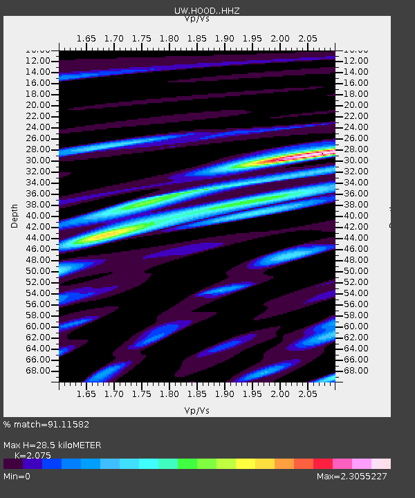
| Estimated Moho Depth: |
28.5 km |
| Estimated Crust Vp/Vs: |
2.08 |
| Assumed Crust Vp: |
6.597 km/s |
| Estimated Crust Vs: |
3.18 km/s |
| Estimated Crust Poisson's Ratio: |
0.35 |
|
| Radial Match: |
91.11582 % |
| Radial Bump: |
400 |
| Transverse Match: |
80.9603 % |
| Transverse Bump: |
400 |
| SOD ConfigId: |
30536071 |
| Insert Time: |
2023-06-08 03:46:04.846 +0000 |
| GWidth: |
2.5 |
| Max Bumps: |
400 |
| Tol: |
0.001 |
|
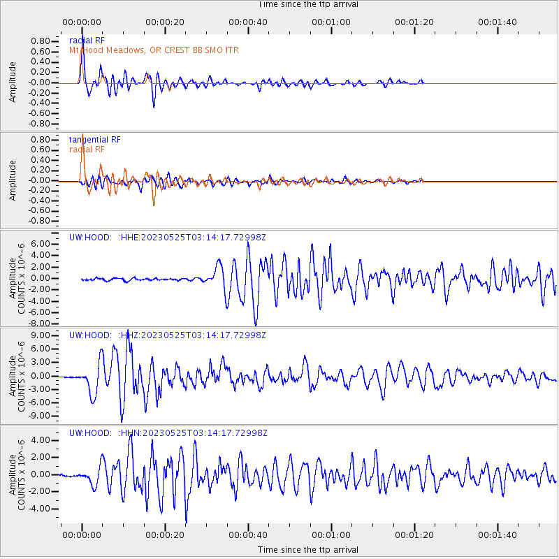
Signal To Noise
| Channel | StoN | STA | LTA |
| UW:HOOD: :HHZ:20230525T03:14:17.72998Z | 31.973104 | 3.457154E-6 | 1.0812694E-7 |
| UW:HOOD: :HHN:20230525T03:14:17.72998Z | 7.5055194 | 1.0022504E-6 | 1.3353512E-7 |
| UW:HOOD: :HHE:20230525T03:14:17.72998Z | 10.896429 | 1.9683948E-6 | 1.8064586E-7 |
| Arrivals |
| Ps | 4.9 SECOND |
| PpPs | 13 SECOND |
| PsPs/PpSs | 18 SECOND |


