You are here: Home > Network List > UW - Pacific Northwest Regional Seismic Network Stations List
> Station VFP Flag Point, OR, USA > Earthquake Result Viewer
VFP Flag Point, OR, USA - Earthquake Result Viewer
| Earthquake location: |
Panama-Colombia Border Region |
| Earthquake latitude/longitude: |
8.9/-77.1 |
| Earthquake time(UTC): |
2023/05/25 (145) 03:05:34 GMT |
| Earthquake Depth: |
10 km |
| Earthquake Magnitude: |
6.6 Mi |
| Earthquake Catalog/Contributor: |
NEIC PDE/at |
|
| Network: |
UW Pacific Northwest Regional Seismic Network |
| Station: |
VFP Flag Point, OR, USA |
| Lat/Lon: |
45.32 N/121.47 W |
| Elevation: |
1722 m |
|
| Distance: |
52.6 deg |
| Az: |
321.611 deg |
| Baz: |
119.577 deg |
| Ray Param: |
0.066651784 |
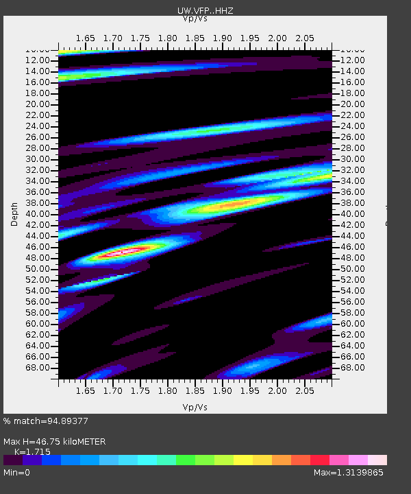
| Estimated Moho Depth: |
46.75 km |
| Estimated Crust Vp/Vs: |
1.72 |
| Assumed Crust Vp: |
6.597 km/s |
| Estimated Crust Vs: |
3.847 km/s |
| Estimated Crust Poisson's Ratio: |
0.24 |
|
| Radial Match: |
94.89377 % |
| Radial Bump: |
400 |
| Transverse Match: |
89.38752 % |
| Transverse Bump: |
400 |
| SOD ConfigId: |
30536071 |
| Insert Time: |
2023-06-08 03:48:25.425 +0000 |
| GWidth: |
2.5 |
| Max Bumps: |
400 |
| Tol: |
0.001 |
|

Signal To Noise
| Channel | StoN | STA | LTA |
| UW:VFP: :HHZ:20230525T03:14:16.880005Z | 38.896545 | 3.9326906E-6 | 1.0110642E-7 |
| UW:VFP: :HHN:20230525T03:14:16.880005Z | 5.1403065 | 1.0749326E-6 | 2.0911837E-7 |
| UW:VFP: :HHE:20230525T03:14:16.880005Z | 11.209511 | 1.9037437E-6 | 1.698329E-7 |
| Arrivals |
| Ps | 5.4 SECOND |
| PpPs | 18 SECOND |
| PsPs/PpSs | 23 SECOND |


