You are here: Home > Network List > WY - Yellowstone Wyoming Seismic Network Stations List
> Station YDD Grant Village, YNP, WY, USA old TA-H17A > Earthquake Result Viewer
YDD Grant Village, YNP, WY, USA old TA-H17A - Earthquake Result Viewer
| Earthquake location: |
Central East Pacific Rise |
| Earthquake latitude/longitude: |
-4.6/-105.9 |
| Earthquake time(UTC): |
2018/10/29 (302) 23:26:09 GMT |
| Earthquake Depth: |
10 km |
| Earthquake Magnitude: |
5.8 Mww |
| Earthquake Catalog/Contributor: |
NEIC PDE/us |
|
| Network: |
WY Yellowstone Wyoming Seismic Network |
| Station: |
YDD Grant Village, YNP, WY, USA old TA-H17A |
| Lat/Lon: |
44.40 N/110.58 W |
| Elevation: |
2400 m |
|
| Distance: |
48.9 deg |
| Az: |
355.563 deg |
| Baz: |
173.824 deg |
| Ray Param: |
0.06903618 |
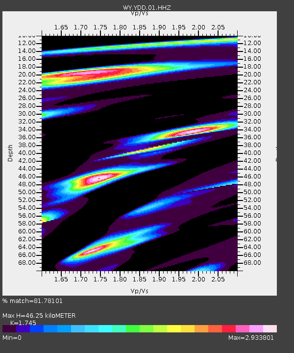
| Estimated Moho Depth: |
46.25 km |
| Estimated Crust Vp/Vs: |
1.75 |
| Assumed Crust Vp: |
6.35 km/s |
| Estimated Crust Vs: |
3.639 km/s |
| Estimated Crust Poisson's Ratio: |
0.26 |
|
| Radial Match: |
81.78101 % |
| Radial Bump: |
400 |
| Transverse Match: |
70.68253 % |
| Transverse Bump: |
400 |
| SOD ConfigId: |
3103472 |
| Insert Time: |
2018-11-12 23:34:37.545 +0000 |
| GWidth: |
2.5 |
| Max Bumps: |
400 |
| Tol: |
0.001 |
|

Signal To Noise
| Channel | StoN | STA | LTA |
| WY:YDD:01:HHZ:20181029T23:34:24.338986Z | 3.0930872 | 1.3536849E-8 | 4.3764845E-9 |
| WY:YDD:01:HHN:20181029T23:34:24.338986Z | 2.7180274 | 1.3648187E-8 | 5.0213576E-9 |
| WY:YDD:01:HHE:20181029T23:34:24.338986Z | 1.2186548 | 9.044751E-9 | 7.4219138E-9 |
| Arrivals |
| Ps | 5.8 SECOND |
| PpPs | 19 SECOND |
| PsPs/PpSs | 25 SECOND |


